You are here: Home > Network List > GS - US Geological Survey Networks Stations List
> Station OK051 E0350 and S34600 Roads, Ralston, OK > Earthquake Result Viewer
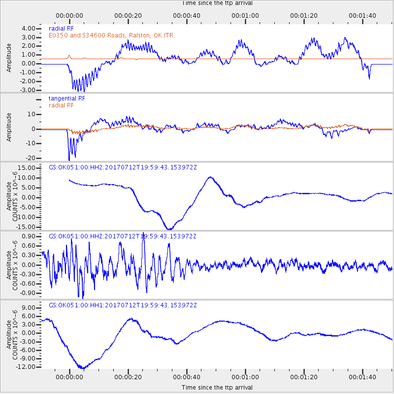
OK051 E0350 and S34600 Roads, Ralston, OK - Earthquake Result Viewer
*The percent match for this event was below the threshold and hence no stack was calculated.
| Earthquake location: |
Sea Of Japan |
| Earthquake latitude/longitude: |
40.9/131.6 |
| Earthquake time(UTC): |
2017/07/12 (193) 19:48:07 GMT |
| Earthquake Depth: |
538 km |
| Earthquake Magnitude: |
5.8 Mww |
| Earthquake Catalog/Contributor: |
NEIC PDE/us |
|
| Network: |
GS US Geological Survey Networks |
| Station: |
OK051 E0350 and S34600 Roads, Ralston, OK |
| Lat/Lon: |
36.51 N/96.84 W |
| Elevation: |
263 m |
|
| Distance: |
91.1 deg |
| Az: |
37.105 deg |
| Baz: |
325.394 deg |
| Ray Param: |
$rayparam |
*The percent match for this event was below the threshold and hence was not used in the summary stack. |
|
| Radial Match: |
60.12745 % |
| Radial Bump: |
400 |
| Transverse Match: |
66.45253 % |
| Transverse Bump: |
400 |
| SOD ConfigId: |
2140511 |
| Insert Time: |
2017-07-26 11:44:16.003 +0000 |
| GWidth: |
2.5 |
| Max Bumps: |
400 |
| Tol: |
0.001 |
|
Signal To Noise
| Channel | StoN | STA | LTA |
| GS:OK051:00:HHZ:20170712T19:59:43.153972Z | 2.9922931 | 5.176797E-7 | 1.7300435E-7 |
| GS:OK051:00:HH1:20170712T19:59:43.153972Z | 5.276198 | 1.7500024E-5 | 3.3167871E-6 |
| GS:OK051:00:HH2:20170712T19:59:43.153972Z | 6.0740857 | 1.7773418E-5 | 2.9261062E-6 |
| Arrivals |
| Ps | |
| PpPs | |
| PsPs/PpSs | |


