You are here: Home > Network List > N4 - Central and EAstern US Network Stations List
> Station E28B Huff Hills, Mandan, ND, USA > Earthquake Result Viewer
E28B Huff Hills, Mandan, ND, USA - Earthquake Result Viewer
| Earthquake location: |
Alaska Peninsula |
| Earthquake latitude/longitude: |
55.2/-158.6 |
| Earthquake time(UTC): |
2020/07/22 (204) 06:12:44 GMT |
| Earthquake Depth: |
13 km |
| Earthquake Magnitude: |
7.4 Mi |
| Earthquake Catalog/Contributor: |
NEIC PDE/at |
|
| Network: |
N4 Central and EAstern US Network |
| Station: |
E28B Huff Hills, Mandan, ND, USA |
| Lat/Lon: |
46.57 N/100.69 W |
| Elevation: |
704 m |
|
| Distance: |
36.5 deg |
| Az: |
78.922 deg |
| Baz: |
305.396 deg |
| Ray Param: |
0.07664523 |
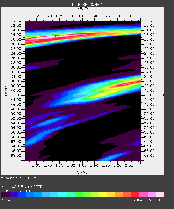
| Estimated Moho Depth: |
16.5 km |
| Estimated Crust Vp/Vs: |
1.73 |
| Assumed Crust Vp: |
6.438 km/s |
| Estimated Crust Vs: |
3.716 km/s |
| Estimated Crust Poisson's Ratio: |
0.25 |
|
| Radial Match: |
95.80775 % |
| Radial Bump: |
240 |
| Transverse Match: |
90.48829 % |
| Transverse Bump: |
400 |
| SOD ConfigId: |
21709731 |
| Insert Time: |
2020-08-05 06:28:16.989 +0000 |
| GWidth: |
2.5 |
| Max Bumps: |
400 |
| Tol: |
0.001 |
|

Signal To Noise
| Channel | StoN | STA | LTA |
| N4:E28B:00:HHZ:20200722T06:19:18.470001Z | 35.833675 | 4.3299256E-6 | 1.2083399E-7 |
| N4:E28B:00:HH1:20200722T06:19:18.470001Z | 3.7382803 | 1.158944E-6 | 3.1002062E-7 |
| N4:E28B:00:HH2:20200722T06:19:18.470001Z | 6.2462234 | 1.8796214E-6 | 3.0092127E-7 |
| Arrivals |
| Ps | 2.0 SECOND |
| PpPs | 6.5 SECOND |
| PsPs/PpSs | 8.5 SECOND |


