You are here: Home > Network List > N4 - Central and EAstern US Network Stations List
> Station G40A Rib Lake, WI, USA > Earthquake Result Viewer
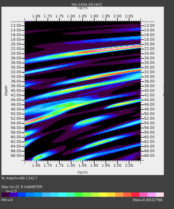
G40A Rib Lake, WI, USA - Earthquake Result Viewer
| Earthquake location: |
Alaska Peninsula |
| Earthquake latitude/longitude: |
55.2/-158.6 |
| Earthquake time(UTC): |
2020/07/22 (204) 06:12:44 GMT |
| Earthquake Depth: |
13 km |
| Earthquake Magnitude: |
7.4 Mi |
| Earthquake Catalog/Contributor: |
NEIC PDE/at |
|
| Network: |
N4 Central and EAstern US Network |
| Station: |
G40A Rib Lake, WI, USA |
| Lat/Lon: |
45.27 N/90.20 W |
| Elevation: |
472 m |
|
| Distance: |
43.2 deg |
| Az: |
73.65 deg |
| Baz: |
308.865 deg |
| Ray Param: |
0.07271628 |
| Estimated Moho Depth: |
21.5 km |
| Estimated Crust Vp/Vs: |
2.00 |
| Assumed Crust Vp: |
6.571 km/s |
| Estimated Crust Vs: |
3.285 km/s |
| Estimated Crust Poisson's Ratio: |
0.33 |
|
| Radial Match: |
98.13417 % |
| Radial Bump: |
337 |
| Transverse Match: |
92.46852 % |
| Transverse Bump: |
400 |
| SOD ConfigId: |
21709731 |
| Insert Time: |
2020-08-05 06:28:24.854 +0000 |
| GWidth: |
2.5 |
| Max Bumps: |
400 |
| Tol: |
0.001 |
|

Signal To Noise
| Channel | StoN | STA | LTA |
| N4:G40A:00:HHZ:20200722T06:20:13.468994Z | 53.801994 | 3.5949602E-6 | 6.6818345E-8 |
| N4:G40A:00:HH1:20200722T06:20:13.468994Z | 29.289589 | 1.555297E-6 | 5.3100674E-8 |
| N4:G40A:00:HH2:20200722T06:20:13.468994Z | 28.633394 | 1.91037E-6 | 6.671825E-8 |
| Arrivals |
| Ps | 3.5 SECOND |
| PpPs | 9.2 SECOND |
| PsPs/PpSs | 13 SECOND |


