You are here: Home > Network List > GS - US Geological Survey Networks Stations List
> Station MT02 Nevada Ogden Rd, Helena Natl Forest, Montana, USA > Earthquake Result Viewer
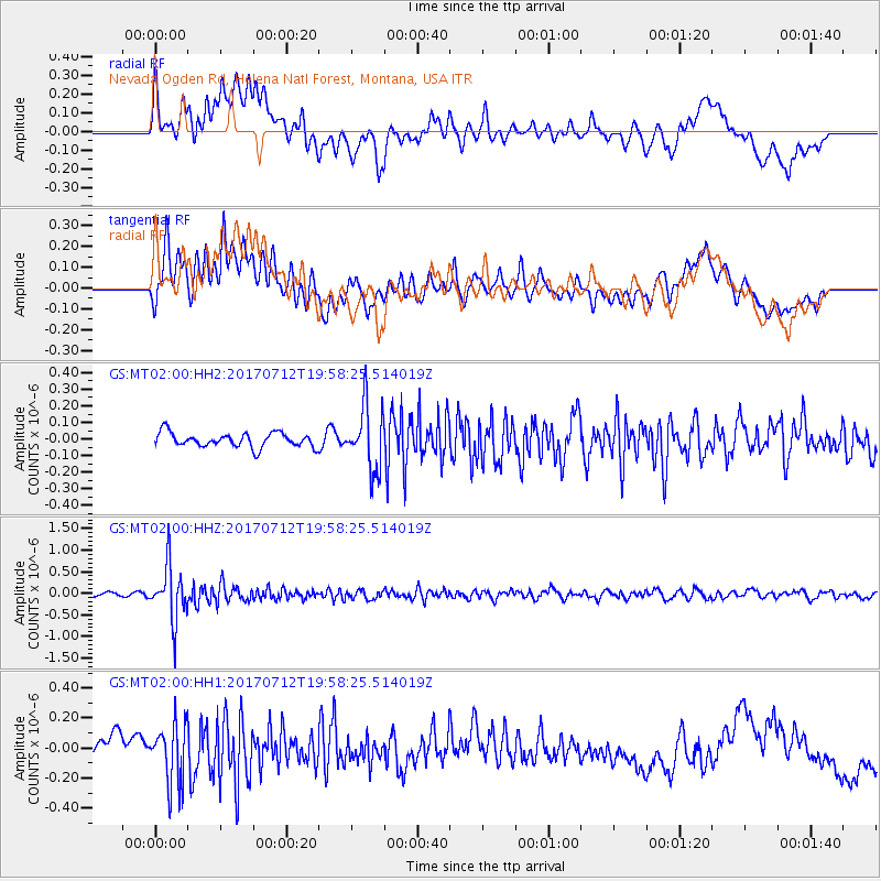
MT02 Nevada Ogden Rd, Helena Natl Forest, Montana, USA - Earthquake Result Viewer
*The percent match for this event was below the threshold and hence no stack was calculated.
| Earthquake location: |
Sea Of Japan |
| Earthquake latitude/longitude: |
40.9/131.6 |
| Earthquake time(UTC): |
2017/07/12 (193) 19:48:07 GMT |
| Earthquake Depth: |
538 km |
| Earthquake Magnitude: |
5.8 Mww |
| Earthquake Catalog/Contributor: |
NEIC PDE/us |
|
| Network: |
GS US Geological Survey Networks |
| Station: |
MT02 Nevada Ogden Rd, Helena Natl Forest, Montana, USA |
| Lat/Lon: |
46.86 N/112.88 W |
| Elevation: |
1672 m |
|
| Distance: |
75.5 deg |
| Az: |
39.776 deg |
| Baz: |
314.995 deg |
| Ray Param: |
$rayparam |
*The percent match for this event was below the threshold and hence was not used in the summary stack. |
|
| Radial Match: |
56.727074 % |
| Radial Bump: |
400 |
| Transverse Match: |
64.92567 % |
| Transverse Bump: |
400 |
| SOD ConfigId: |
2140511 |
| Insert Time: |
2017-07-26 11:44:33.035 +0000 |
| GWidth: |
2.5 |
| Max Bumps: |
400 |
| Tol: |
0.001 |
|
Signal To Noise
| Channel | StoN | STA | LTA |
| GS:MT02:00:HHZ:20170712T19:58:25.514019Z | 13.372479 | 6.3342645E-7 | 4.7367912E-8 |
| GS:MT02:00:HH1:20170712T19:58:25.514019Z | 2.4932795 | 1.9985704E-7 | 8.01583E-8 |
| GS:MT02:00:HH2:20170712T19:58:25.514019Z | 4.4240584 | 1.9064274E-7 | 4.3092275E-8 |
| Arrivals |
| Ps | |
| PpPs | |
| PsPs/PpSs | |


