You are here: Home > Network List > N4 - Central and EAstern US Network Stations List
> Station R40B Maddies Station, St. Elizabeth, MO, USA > Earthquake Result Viewer
R40B Maddies Station, St. Elizabeth, MO, USA - Earthquake Result Viewer
| Earthquake location: |
Alaska Peninsula |
| Earthquake latitude/longitude: |
55.2/-158.6 |
| Earthquake time(UTC): |
2020/07/22 (204) 06:12:44 GMT |
| Earthquake Depth: |
13 km |
| Earthquake Magnitude: |
7.4 Mi |
| Earthquake Catalog/Contributor: |
NEIC PDE/at |
|
| Network: |
N4 Central and EAstern US Network |
| Station: |
R40B Maddies Station, St. Elizabeth, MO, USA |
| Lat/Lon: |
38.29 N/92.27 W |
| Elevation: |
218 m |
|
| Distance: |
46.6 deg |
| Az: |
82.518 deg |
| Baz: |
313.781 deg |
| Ray Param: |
0.07052417 |
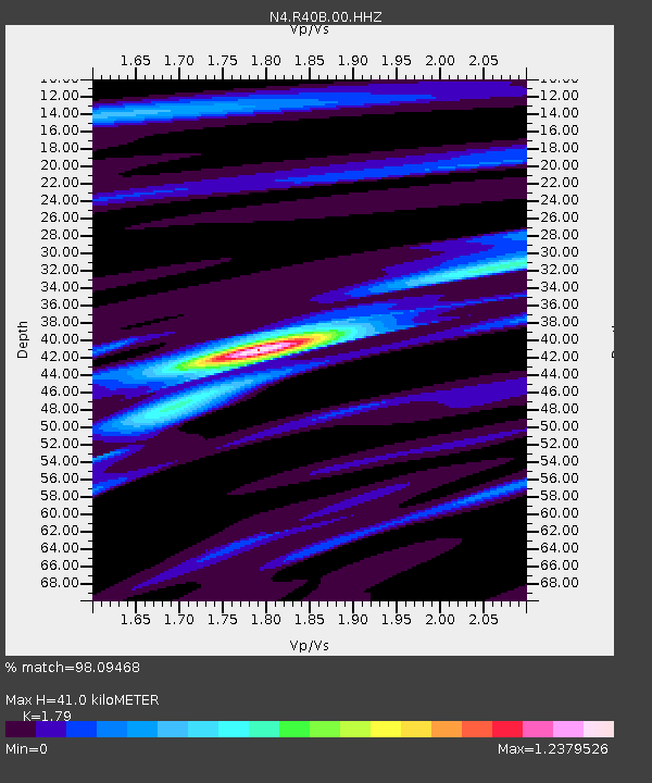
| Estimated Moho Depth: |
41.0 km |
| Estimated Crust Vp/Vs: |
1.79 |
| Assumed Crust Vp: |
6.498 km/s |
| Estimated Crust Vs: |
3.63 km/s |
| Estimated Crust Poisson's Ratio: |
0.27 |
|
| Radial Match: |
98.09468 % |
| Radial Bump: |
207 |
| Transverse Match: |
85.44122 % |
| Transverse Bump: |
400 |
| SOD ConfigId: |
21709731 |
| Insert Time: |
2020-08-05 06:29:53.719 +0000 |
| GWidth: |
2.5 |
| Max Bumps: |
400 |
| Tol: |
0.001 |
|

Signal To Noise
| Channel | StoN | STA | LTA |
| N4:R40B:00:HHZ:20200722T06:20:40.890015Z | 28.50605 | 2.3562563E-6 | 8.265812E-8 |
| N4:R40B:00:HH1:20200722T06:20:40.890015Z | 12.879581 | 8.9120414E-7 | 6.919512E-8 |
| N4:R40B:00:HH2:20200722T06:20:40.890015Z | 14.084859 | 8.5640715E-7 | 6.080339E-8 |
| Arrivals |
| Ps | 5.3 SECOND |
| PpPs | 17 SECOND |
| PsPs/PpSs | 22 SECOND |


