You are here: Home > Network List > N4 - Central and EAstern US Network Stations List
> Station R58B Mineral, VA, USA > Earthquake Result Viewer
R58B Mineral, VA, USA - Earthquake Result Viewer
| Earthquake location: |
Alaska Peninsula |
| Earthquake latitude/longitude: |
55.2/-158.6 |
| Earthquake time(UTC): |
2020/07/22 (204) 06:12:44 GMT |
| Earthquake Depth: |
13 km |
| Earthquake Magnitude: |
7.4 Mi |
| Earthquake Catalog/Contributor: |
NEIC PDE/at |
|
| Network: |
N4 Central and EAstern US Network |
| Station: |
R58B Mineral, VA, USA |
| Lat/Lon: |
37.96 N/77.88 W |
| Elevation: |
116 m |
|
| Distance: |
54.9 deg |
| Az: |
72.462 deg |
| Baz: |
316.269 deg |
| Ray Param: |
0.065153815 |
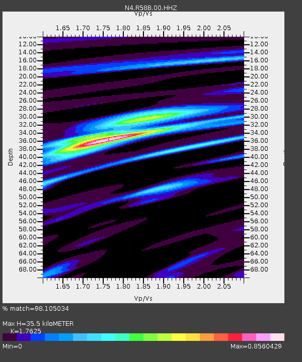
| Estimated Moho Depth: |
35.5 km |
| Estimated Crust Vp/Vs: |
1.76 |
| Assumed Crust Vp: |
6.565 km/s |
| Estimated Crust Vs: |
3.725 km/s |
| Estimated Crust Poisson's Ratio: |
0.26 |
|
| Radial Match: |
98.105034 % |
| Radial Bump: |
183 |
| Transverse Match: |
94.949905 % |
| Transverse Bump: |
400 |
| SOD ConfigId: |
21709731 |
| Insert Time: |
2020-08-05 06:29:58.963 +0000 |
| GWidth: |
2.5 |
| Max Bumps: |
400 |
| Tol: |
0.001 |
|

Signal To Noise
| Channel | StoN | STA | LTA |
| N4:R58B:00:HHZ:20200722T06:21:43.119995Z | 40.28608 | 3.8057156E-6 | 9.4467254E-8 |
| N4:R58B:00:HH1:20200722T06:21:43.119995Z | 25.689018 | 1.4102118E-6 | 5.4895512E-8 |
| N4:R58B:00:HH2:20200722T06:21:43.119995Z | 12.5865555 | 1.2803555E-6 | 1.01724055E-7 |
| Arrivals |
| Ps | 4.4 SECOND |
| PpPs | 14 SECOND |
| PsPs/PpSs | 18 SECOND |


