You are here: Home > Network List > N4 - Central and EAstern US Network Stations List
> Station SFIN Lafayette, IN, USA > Earthquake Result Viewer
SFIN Lafayette, IN, USA - Earthquake Result Viewer
| Earthquake location: |
Alaska Peninsula |
| Earthquake latitude/longitude: |
55.2/-158.6 |
| Earthquake time(UTC): |
2020/07/22 (204) 06:12:44 GMT |
| Earthquake Depth: |
13 km |
| Earthquake Magnitude: |
7.4 Mi |
| Earthquake Catalog/Contributor: |
NEIC PDE/at |
|
| Network: |
N4 Central and EAstern US Network |
| Station: |
SFIN Lafayette, IN, USA |
| Lat/Lon: |
40.38 N/87.10 W |
| Elevation: |
165 m |
|
| Distance: |
48.1 deg |
| Az: |
76.712 deg |
| Baz: |
313.112 deg |
| Ray Param: |
0.06957649 |
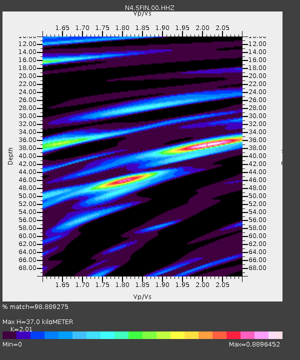
| Estimated Moho Depth: |
37.0 km |
| Estimated Crust Vp/Vs: |
2.01 |
| Assumed Crust Vp: |
6.498 km/s |
| Estimated Crust Vs: |
3.233 km/s |
| Estimated Crust Poisson's Ratio: |
0.34 |
|
| Radial Match: |
98.889275 % |
| Radial Bump: |
284 |
| Transverse Match: |
92.01967 % |
| Transverse Bump: |
400 |
| SOD ConfigId: |
21709731 |
| Insert Time: |
2020-08-05 06:30:10.472 +0000 |
| GWidth: |
2.5 |
| Max Bumps: |
400 |
| Tol: |
0.001 |
|

Signal To Noise
| Channel | StoN | STA | LTA |
| N4:SFIN:00:HHZ:20200722T06:20:52.399994Z | 34.990906 | 4.4744547E-6 | 1.278748E-7 |
| N4:SFIN:00:HH1:20200722T06:20:52.399994Z | 19.674438 | 1.4852003E-6 | 7.548883E-8 |
| N4:SFIN:00:HH2:20200722T06:20:52.399994Z | 22.460312 | 1.6388077E-6 | 7.2964596E-8 |
| Arrivals |
| Ps | 6.1 SECOND |
| PpPs | 16 SECOND |
| PsPs/PpSs | 22 SECOND |


