You are here: Home > Network List > NE - New England Seismic Network Stations List
> Station WVL Waterville, ME, USA > Earthquake Result Viewer
WVL Waterville, ME, USA - Earthquake Result Viewer
| Earthquake location: |
Alaska Peninsula |
| Earthquake latitude/longitude: |
55.2/-158.6 |
| Earthquake time(UTC): |
2020/07/22 (204) 06:12:44 GMT |
| Earthquake Depth: |
13 km |
| Earthquake Magnitude: |
7.4 Mi |
| Earthquake Catalog/Contributor: |
NEIC PDE/at |
|
| Network: |
NE New England Seismic Network |
| Station: |
WVL Waterville, ME, USA |
| Lat/Lon: |
44.56 N/69.66 W |
| Elevation: |
50 m |
|
| Distance: |
54.5 deg |
| Az: |
61.391 deg |
| Baz: |
315.271 deg |
| Ray Param: |
0.065412834 |
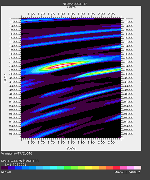
| Estimated Moho Depth: |
33.75 km |
| Estimated Crust Vp/Vs: |
1.80 |
| Assumed Crust Vp: |
6.419 km/s |
| Estimated Crust Vs: |
3.576 km/s |
| Estimated Crust Poisson's Ratio: |
0.27 |
|
| Radial Match: |
97.51046 % |
| Radial Bump: |
400 |
| Transverse Match: |
83.36617 % |
| Transverse Bump: |
400 |
| SOD ConfigId: |
21709731 |
| Insert Time: |
2020-08-05 06:31:11.689 +0000 |
| GWidth: |
2.5 |
| Max Bumps: |
400 |
| Tol: |
0.001 |
|

Signal To Noise
| Channel | StoN | STA | LTA |
| NE:WVL:00:HHZ:20200722T06:21:40.249023Z | 29.837471 | 4.5839406E-6 | 1.5363034E-7 |
| NE:WVL:00:HH1:20200722T06:21:40.249023Z | 19.632385 | 1.8142078E-6 | 9.240894E-8 |
| NE:WVL:00:HH2:20200722T06:21:40.249023Z | 19.911484 | 1.6374394E-6 | 8.223593E-8 |
| Arrivals |
| Ps | 4.4 SECOND |
| PpPs | 14 SECOND |
| PsPs/PpSs | 18 SECOND |


