You are here: Home > Network List > NM - Cooperative New Madrid Seismic Network Stations List
> Station X502 Temporary Arkansas > Earthquake Result Viewer
X502 Temporary Arkansas - Earthquake Result Viewer
| Earthquake location: |
Alaska Peninsula |
| Earthquake latitude/longitude: |
55.2/-158.6 |
| Earthquake time(UTC): |
2020/07/22 (204) 06:12:44 GMT |
| Earthquake Depth: |
13 km |
| Earthquake Magnitude: |
7.4 Mi |
| Earthquake Catalog/Contributor: |
NEIC PDE/at |
|
| Network: |
NM Cooperative New Madrid Seismic Network |
| Station: |
X502 Temporary Arkansas |
| Lat/Lon: |
35.49 N/92.39 W |
| Elevation: |
344 m |
|
| Distance: |
48.5 deg |
| Az: |
85.301 deg |
| Baz: |
315.588 deg |
| Ray Param: |
0.069303885 |
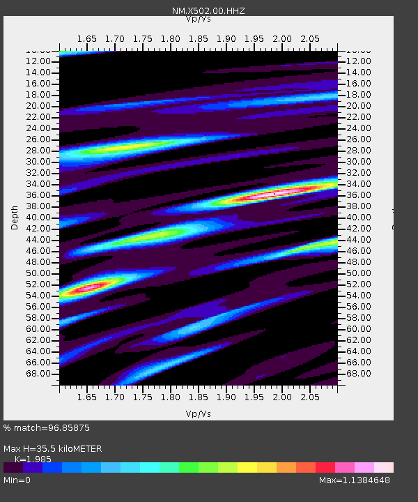
| Estimated Moho Depth: |
35.5 km |
| Estimated Crust Vp/Vs: |
1.99 |
| Assumed Crust Vp: |
6.498 km/s |
| Estimated Crust Vs: |
3.273 km/s |
| Estimated Crust Poisson's Ratio: |
0.33 |
|
| Radial Match: |
96.85875 % |
| Radial Bump: |
354 |
| Transverse Match: |
83.954254 % |
| Transverse Bump: |
400 |
| SOD ConfigId: |
21709731 |
| Insert Time: |
2020-08-05 06:31:47.681 +0000 |
| GWidth: |
2.5 |
| Max Bumps: |
400 |
| Tol: |
0.001 |
|

Signal To Noise
| Channel | StoN | STA | LTA |
| NM:X502:00:HHZ:20200722T06:20:55.619995Z | 10.066927 | 2.5696916E-6 | 2.5526077E-7 |
| NM:X502:00:HHN:20200722T06:20:55.619995Z | 3.3077574 | 9.89782E-7 | 2.9923055E-7 |
| NM:X502:00:HHE:20200722T06:20:55.619995Z | 3.8647425 | 9.612118E-7 | 2.48713E-7 |
| Arrivals |
| Ps | 5.7 SECOND |
| PpPs | 15 SECOND |
| PsPs/PpSs | 21 SECOND |


