You are here: Home > Network List > O2 - Oklahoma Consolidated Temporary Seismic Networks Stations List
> Station FW04 Hopeton, Oklahoma, USA > Earthquake Result Viewer
FW04 Hopeton, Oklahoma, USA - Earthquake Result Viewer
| Earthquake location: |
Alaska Peninsula |
| Earthquake latitude/longitude: |
55.2/-158.6 |
| Earthquake time(UTC): |
2020/07/22 (204) 06:12:44 GMT |
| Earthquake Depth: |
13 km |
| Earthquake Magnitude: |
7.4 Mi |
| Earthquake Catalog/Contributor: |
NEIC PDE/at |
|
| Network: |
O2 Oklahoma Consolidated Temporary Seismic Networks |
| Station: |
FW04 Hopeton, Oklahoma, USA |
| Lat/Lon: |
36.60 N/98.67 W |
| Elevation: |
448 m |
|
| Distance: |
44.1 deg |
| Az: |
89.206 deg |
| Baz: |
314.606 deg |
| Ray Param: |
0.07210294 |
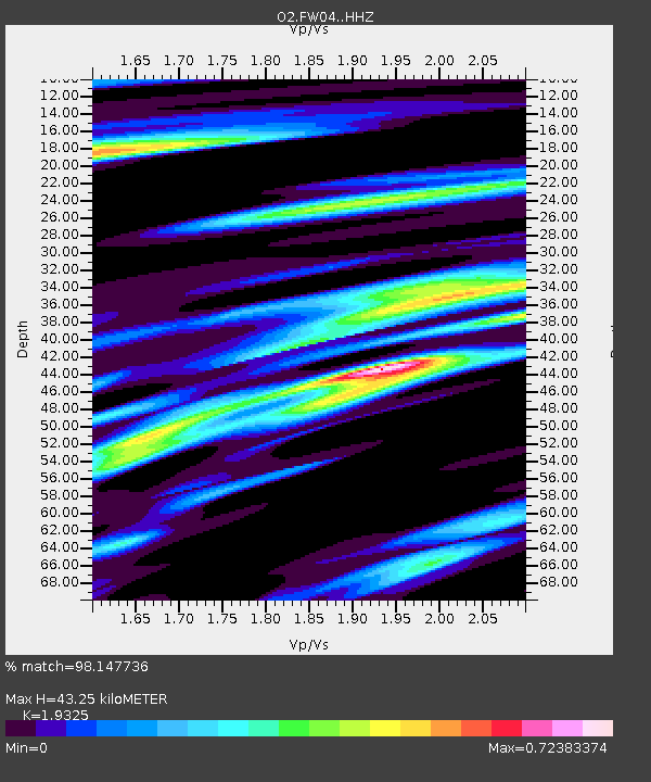
| Estimated Moho Depth: |
43.25 km |
| Estimated Crust Vp/Vs: |
1.93 |
| Assumed Crust Vp: |
6.426 km/s |
| Estimated Crust Vs: |
3.325 km/s |
| Estimated Crust Poisson's Ratio: |
0.32 |
|
| Radial Match: |
98.147736 % |
| Radial Bump: |
219 |
| Transverse Match: |
92.06338 % |
| Transverse Bump: |
400 |
| SOD ConfigId: |
21709731 |
| Insert Time: |
2020-08-05 06:33:16.809 +0000 |
| GWidth: |
2.5 |
| Max Bumps: |
400 |
| Tol: |
0.001 |
|

Signal To Noise
| Channel | StoN | STA | LTA |
| O2:FW04: :HHZ:20200722T06:20:21.299988Z | 20.296066 | 2.5794866E-6 | 1.2709295E-7 |
| O2:FW04: :HHN:20200722T06:20:21.299988Z | 9.325537 | 9.627389E-7 | 1.0323684E-7 |
| O2:FW04: :HHE:20200722T06:20:21.299988Z | 8.607742 | 1.0309905E-6 | 1.197748E-7 |
| Arrivals |
| Ps | 6.7 SECOND |
| PpPs | 19 SECOND |
| PsPs/PpSs | 25 SECOND |


