You are here: Home > Network List > O2 - Oklahoma Consolidated Temporary Seismic Networks Stations List
> Station PERK Perkins, Oklahoma, USA > Earthquake Result Viewer
PERK Perkins, Oklahoma, USA - Earthquake Result Viewer
| Earthquake location: |
Alaska Peninsula |
| Earthquake latitude/longitude: |
55.2/-158.6 |
| Earthquake time(UTC): |
2020/07/22 (204) 06:12:44 GMT |
| Earthquake Depth: |
13 km |
| Earthquake Magnitude: |
7.4 Mi |
| Earthquake Catalog/Contributor: |
NEIC PDE/at |
|
| Network: |
O2 Oklahoma Consolidated Temporary Seismic Networks |
| Station: |
PERK Perkins, Oklahoma, USA |
| Lat/Lon: |
35.93 N/97.13 W |
| Elevation: |
288 m |
|
| Distance: |
45.5 deg |
| Az: |
88.637 deg |
| Baz: |
315.106 deg |
| Ray Param: |
0.07123514 |
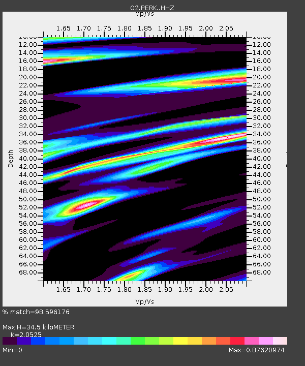
| Estimated Moho Depth: |
34.5 km |
| Estimated Crust Vp/Vs: |
2.05 |
| Assumed Crust Vp: |
6.426 km/s |
| Estimated Crust Vs: |
3.131 km/s |
| Estimated Crust Poisson's Ratio: |
0.34 |
|
| Radial Match: |
98.596176 % |
| Radial Bump: |
225 |
| Transverse Match: |
92.48543 % |
| Transverse Bump: |
400 |
| SOD ConfigId: |
21709731 |
| Insert Time: |
2020-08-05 06:33:30.229 +0000 |
| GWidth: |
2.5 |
| Max Bumps: |
400 |
| Tol: |
0.001 |
|

Signal To Noise
| Channel | StoN | STA | LTA |
| O2:PERK: :HHZ:20200722T06:20:32.045013Z | 34.063282 | 2.4052779E-6 | 7.0612046E-8 |
| O2:PERK: :HHN:20200722T06:20:32.045013Z | 6.469634 | 7.203225E-7 | 1.11338984E-7 |
| O2:PERK: :HHE:20200722T06:20:32.045013Z | 7.2980633 | 8.7078206E-7 | 1.1931687E-7 |
| Arrivals |
| Ps | 6.0 SECOND |
| PpPs | 16 SECOND |
| PsPs/PpSs | 21 SECOND |


