You are here: Home > Network List > O2 - Oklahoma Consolidated Temporary Seismic Networks Stations List
> Station PW01 Pawnee, Oklahoma > Earthquake Result Viewer
PW01 Pawnee, Oklahoma - Earthquake Result Viewer
| Earthquake location: |
Alaska Peninsula |
| Earthquake latitude/longitude: |
55.2/-158.6 |
| Earthquake time(UTC): |
2020/07/22 (204) 06:12:44 GMT |
| Earthquake Depth: |
13 km |
| Earthquake Magnitude: |
7.4 Mi |
| Earthquake Catalog/Contributor: |
NEIC PDE/at |
|
| Network: |
O2 Oklahoma Consolidated Temporary Seismic Networks |
| Station: |
PW01 Pawnee, Oklahoma |
| Lat/Lon: |
36.40 N/96.93 W |
| Elevation: |
322 m |
|
| Distance: |
45.3 deg |
| Az: |
88.004 deg |
| Baz: |
314.78 deg |
| Ray Param: |
0.07138268 |
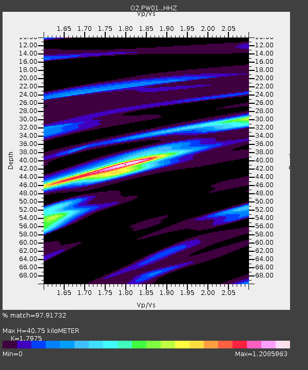
| Estimated Moho Depth: |
40.75 km |
| Estimated Crust Vp/Vs: |
1.80 |
| Assumed Crust Vp: |
6.483 km/s |
| Estimated Crust Vs: |
3.606 km/s |
| Estimated Crust Poisson's Ratio: |
0.28 |
|
| Radial Match: |
97.91732 % |
| Radial Bump: |
171 |
| Transverse Match: |
94.46454 % |
| Transverse Bump: |
396 |
| SOD ConfigId: |
21709731 |
| Insert Time: |
2020-08-05 06:33:32.737 +0000 |
| GWidth: |
2.5 |
| Max Bumps: |
400 |
| Tol: |
0.001 |
|

Signal To Noise
| Channel | StoN | STA | LTA |
| O2:PW01: :HHZ:20200722T06:20:30.304993Z | 18.504517 | 2.1859014E-6 | 1.18128E-7 |
| O2:PW01: :HHN:20200722T06:20:30.304993Z | 16.889194 | 1.0332486E-6 | 6.117809E-8 |
| O2:PW01: :HHE:20200722T06:20:30.304993Z | 7.4247456 | 6.505629E-7 | 8.762091E-8 |
| Arrivals |
| Ps | 5.3 SECOND |
| PpPs | 16 SECOND |
| PsPs/PpSs | 22 SECOND |


