You are here: Home > Network List > O2 - Oklahoma Consolidated Temporary Seismic Networks Stations List
> Station PW06 Pawnee, Oklahoma, USA > Earthquake Result Viewer
PW06 Pawnee, Oklahoma, USA - Earthquake Result Viewer
| Earthquake location: |
Alaska Peninsula |
| Earthquake latitude/longitude: |
55.2/-158.6 |
| Earthquake time(UTC): |
2020/07/22 (204) 06:12:44 GMT |
| Earthquake Depth: |
13 km |
| Earthquake Magnitude: |
7.4 Mi |
| Earthquake Catalog/Contributor: |
NEIC PDE/at |
|
| Network: |
O2 Oklahoma Consolidated Temporary Seismic Networks |
| Station: |
PW06 Pawnee, Oklahoma, USA |
| Lat/Lon: |
36.42 N/96.97 W |
| Elevation: |
303 m |
|
| Distance: |
45.2 deg |
| Az: |
88.019 deg |
| Baz: |
314.765 deg |
| Ray Param: |
0.07140767 |
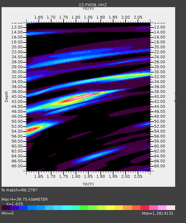
| Estimated Moho Depth: |
39.75 km |
| Estimated Crust Vp/Vs: |
1.83 |
| Assumed Crust Vp: |
6.483 km/s |
| Estimated Crust Vs: |
3.552 km/s |
| Estimated Crust Poisson's Ratio: |
0.29 |
|
| Radial Match: |
98.2797 % |
| Radial Bump: |
238 |
| Transverse Match: |
93.75996 % |
| Transverse Bump: |
400 |
| SOD ConfigId: |
21709731 |
| Insert Time: |
2020-08-05 06:33:35.700 +0000 |
| GWidth: |
2.5 |
| Max Bumps: |
400 |
| Tol: |
0.001 |
|

Signal To Noise
| Channel | StoN | STA | LTA |
| O2:PW06: :HHZ:20200722T06:20:30.005005Z | 18.828379 | 2.1520439E-6 | 1.1429789E-7 |
| O2:PW06: :HHN:20200722T06:20:30.005005Z | 10.091401 | 6.9799387E-7 | 6.916719E-8 |
| O2:PW06: :HHE:20200722T06:20:30.005005Z | 12.721681 | 1.0835344E-6 | 8.517227E-8 |
| Arrivals |
| Ps | 5.4 SECOND |
| PpPs | 16 SECOND |
| PsPs/PpSs | 22 SECOND |


