You are here: Home > Network List > O2 - Oklahoma Consolidated Temporary Seismic Networks Stations List
> Station SC03 Ninnekah, Oklahoma, USA > Earthquake Result Viewer
SC03 Ninnekah, Oklahoma, USA - Earthquake Result Viewer
| Earthquake location: |
Alaska Peninsula |
| Earthquake latitude/longitude: |
55.2/-158.6 |
| Earthquake time(UTC): |
2020/07/22 (204) 06:12:44 GMT |
| Earthquake Depth: |
13 km |
| Earthquake Magnitude: |
7.4 Mi |
| Earthquake Catalog/Contributor: |
NEIC PDE/at |
|
| Network: |
O2 Oklahoma Consolidated Temporary Seismic Networks |
| Station: |
SC03 Ninnekah, Oklahoma, USA |
| Lat/Lon: |
34.94 N/97.85 W |
| Elevation: |
349 m |
|
| Distance: |
45.8 deg |
| Az: |
90.187 deg |
| Baz: |
315.775 deg |
| Ray Param: |
0.07104321 |
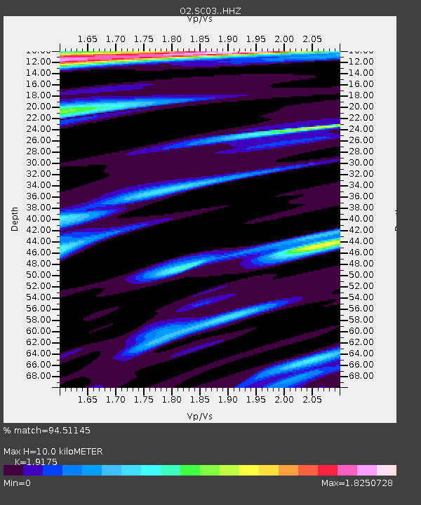
| Estimated Moho Depth: |
10.0 km |
| Estimated Crust Vp/Vs: |
1.92 |
| Assumed Crust Vp: |
6.426 km/s |
| Estimated Crust Vs: |
3.351 km/s |
| Estimated Crust Poisson's Ratio: |
0.31 |
|
| Radial Match: |
94.51145 % |
| Radial Bump: |
383 |
| Transverse Match: |
88.83742 % |
| Transverse Bump: |
400 |
| SOD ConfigId: |
21709731 |
| Insert Time: |
2020-08-05 06:33:53.055 +0000 |
| GWidth: |
2.5 |
| Max Bumps: |
400 |
| Tol: |
0.001 |
|

Signal To Noise
| Channel | StoN | STA | LTA |
| O2:SC03: :HHZ:20200722T06:20:34.329987Z | 14.111455 | 4.07196E-6 | 2.8855706E-7 |
| O2:SC03: :HHN:20200722T06:20:34.329987Z | 2.7357225 | 1.0383596E-6 | 3.795559E-7 |
| O2:SC03: :HHE:20200722T06:20:34.329987Z | 5.3142743 | 9.885317E-7 | 1.8601445E-7 |
| Arrivals |
| Ps | 1.5 SECOND |
| PpPs | 4.3 SECOND |
| PsPs/PpSs | 5.8 SECOND |


