You are here: Home > Network List > IU - Global Seismograph Network (GSN - IRIS/USGS) Stations List
> Station PMG Port Moresby, New Guinea > Earthquake Result Viewer
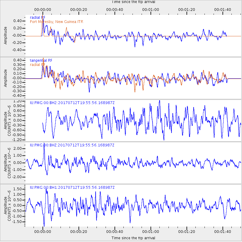
PMG Port Moresby, New Guinea - Earthquake Result Viewer
*The percent match for this event was below the threshold and hence no stack was calculated.
| Earthquake location: |
Sea Of Japan |
| Earthquake latitude/longitude: |
40.9/131.6 |
| Earthquake time(UTC): |
2017/07/12 (193) 19:48:07 GMT |
| Earthquake Depth: |
538 km |
| Earthquake Magnitude: |
5.8 Mww |
| Earthquake Catalog/Contributor: |
NEIC PDE/us |
|
| Network: |
IU Global Seismograph Network (GSN - IRIS/USGS) |
| Station: |
PMG Port Moresby, New Guinea |
| Lat/Lon: |
9.40 S/147.16 E |
| Elevation: |
90 m |
|
| Distance: |
52.0 deg |
| Az: |
160.424 deg |
| Baz: |
345.074 deg |
| Ray Param: |
$rayparam |
*The percent match for this event was below the threshold and hence was not used in the summary stack. |
|
| Radial Match: |
54.100574 % |
| Radial Bump: |
400 |
| Transverse Match: |
61.182957 % |
| Transverse Bump: |
400 |
| SOD ConfigId: |
2140511 |
| Insert Time: |
2017-07-26 11:46:26.842 +0000 |
| GWidth: |
2.5 |
| Max Bumps: |
400 |
| Tol: |
0.001 |
|
Signal To Noise
| Channel | StoN | STA | LTA |
| IU:PMG:00:BHZ:20170712T19:55:56.168987Z | 3.1058238 | 1.0447202E-6 | 3.3637457E-7 |
| IU:PMG:00:BH1:20170712T19:55:56.168987Z | 3.255587 | 9.2126936E-7 | 2.8298103E-7 |
| IU:PMG:00:BH2:20170712T19:55:56.168987Z | 1.1423482 | 4.641182E-7 | 4.0628436E-7 |
| Arrivals |
| Ps | |
| PpPs | |
| PsPs/PpSs | |


