You are here: Home > Network List > OK - Oklahoma Seismic Network Stations List
> Station DEOK Depew, Oklahoma, USA > Earthquake Result Viewer
DEOK Depew, Oklahoma, USA - Earthquake Result Viewer
| Earthquake location: |
Alaska Peninsula |
| Earthquake latitude/longitude: |
55.2/-158.6 |
| Earthquake time(UTC): |
2020/07/22 (204) 06:12:44 GMT |
| Earthquake Depth: |
13 km |
| Earthquake Magnitude: |
7.4 Mi |
| Earthquake Catalog/Contributor: |
NEIC PDE/at |
|
| Network: |
OK Oklahoma Seismic Network |
| Station: |
DEOK Depew, Oklahoma, USA |
| Lat/Lon: |
35.84 N/96.50 W |
| Elevation: |
291 m |
|
| Distance: |
45.9 deg |
| Az: |
88.211 deg |
| Baz: |
315.178 deg |
| Ray Param: |
0.070973545 |
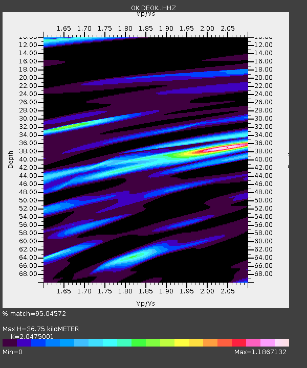
| Estimated Moho Depth: |
36.75 km |
| Estimated Crust Vp/Vs: |
2.05 |
| Assumed Crust Vp: |
6.426 km/s |
| Estimated Crust Vs: |
3.139 km/s |
| Estimated Crust Poisson's Ratio: |
0.34 |
|
| Radial Match: |
95.04572 % |
| Radial Bump: |
315 |
| Transverse Match: |
88.912155 % |
| Transverse Bump: |
400 |
| SOD ConfigId: |
21709731 |
| Insert Time: |
2020-08-05 06:34:49.440 +0000 |
| GWidth: |
2.5 |
| Max Bumps: |
400 |
| Tol: |
0.001 |
|

Signal To Noise
| Channel | StoN | STA | LTA |
| OK:DEOK: :HHZ:20200722T06:20:35.369995Z | 12.662388 | 2.5436336E-6 | 2.0088103E-7 |
| OK:DEOK: :HHN:20200722T06:20:35.369995Z | 1.7251776 | 1.069833E-6 | 6.201292E-7 |
| OK:DEOK: :HHE:20200722T06:20:35.369995Z | 1.168632 | 8.8984876E-7 | 7.614448E-7 |
| Arrivals |
| Ps | 6.3 SECOND |
| PpPs | 17 SECOND |
| PsPs/PpSs | 23 SECOND |


