You are here: Home > Network List > OK - Oklahoma Seismic Network Stations List
> Station ELIS Ellis County, Oklahoma > Earthquake Result Viewer
ELIS Ellis County, Oklahoma - Earthquake Result Viewer
| Earthquake location: |
Alaska Peninsula |
| Earthquake latitude/longitude: |
55.2/-158.6 |
| Earthquake time(UTC): |
2020/07/22 (204) 06:12:44 GMT |
| Earthquake Depth: |
13 km |
| Earthquake Magnitude: |
7.4 Mi |
| Earthquake Catalog/Contributor: |
NEIC PDE/at |
|
| Network: |
OK Oklahoma Seismic Network |
| Station: |
ELIS Ellis County, Oklahoma |
| Lat/Lon: |
36.07 N/99.42 W |
| Elevation: |
641 m |
|
| Distance: |
44.1 deg |
| Az: |
90.361 deg |
| Baz: |
314.991 deg |
| Ray Param: |
0.07213657 |
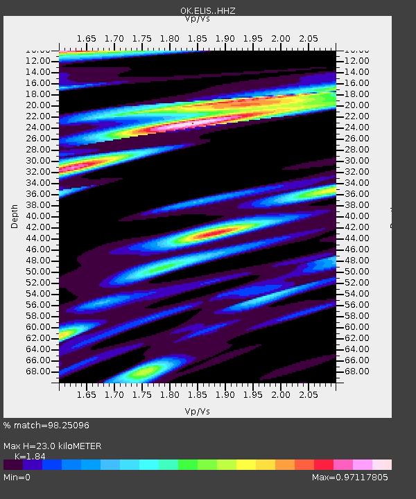
| Estimated Moho Depth: |
23.0 km |
| Estimated Crust Vp/Vs: |
1.84 |
| Assumed Crust Vp: |
6.426 km/s |
| Estimated Crust Vs: |
3.492 km/s |
| Estimated Crust Poisson's Ratio: |
0.29 |
|
| Radial Match: |
98.25096 % |
| Radial Bump: |
358 |
| Transverse Match: |
92.30032 % |
| Transverse Bump: |
400 |
| SOD ConfigId: |
21709731 |
| Insert Time: |
2020-08-05 06:34:51.148 +0000 |
| GWidth: |
2.5 |
| Max Bumps: |
400 |
| Tol: |
0.001 |
|

Signal To Noise
| Channel | StoN | STA | LTA |
| OK:ELIS: :HHZ:20200722T06:20:20.829987Z | 17.373026 | 2.7249118E-6 | 1.5684728E-7 |
| OK:ELIS: :HHN:20200722T06:20:20.829987Z | 1.3117542 | 6.522277E-7 | 4.972179E-7 |
| OK:ELIS: :HHE:20200722T06:20:20.829987Z | 4.750401 | 1.0784266E-6 | 2.2701803E-7 |
| Arrivals |
| Ps | 3.2 SECOND |
| PpPs | 9.5 SECOND |
| PsPs/PpSs | 13 SECOND |


