You are here: Home > Network List > OX - North-East Italy Seismic Network Stations List
> Station PRED Cave del Predil > Earthquake Result Viewer
PRED Cave del Predil - Earthquake Result Viewer
| Earthquake location: |
Alaska Peninsula |
| Earthquake latitude/longitude: |
55.2/-158.6 |
| Earthquake time(UTC): |
2020/07/22 (204) 06:12:44 GMT |
| Earthquake Depth: |
13 km |
| Earthquake Magnitude: |
7.4 Mi |
| Earthquake Catalog/Contributor: |
NEIC PDE/at |
|
| Network: |
OX North-East Italy Seismic Network |
| Station: |
PRED Cave del Predil |
| Lat/Lon: |
46.44 N/13.56 E |
| Elevation: |
902 m |
|
| Distance: |
78.5 deg |
| Az: |
5.525 deg |
| Baz: |
355.424 deg |
| Ray Param: |
0.049600802 |
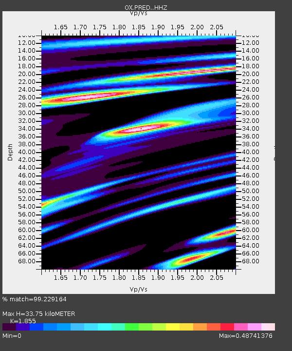
| Estimated Moho Depth: |
33.75 km |
| Estimated Crust Vp/Vs: |
1.86 |
| Assumed Crust Vp: |
6.35 km/s |
| Estimated Crust Vs: |
3.423 km/s |
| Estimated Crust Poisson's Ratio: |
0.30 |
|
| Radial Match: |
99.229164 % |
| Radial Bump: |
175 |
| Transverse Match: |
91.5182 % |
| Transverse Bump: |
400 |
| SOD ConfigId: |
21709731 |
| Insert Time: |
2020-08-05 06:35:27.407 +0000 |
| GWidth: |
2.5 |
| Max Bumps: |
400 |
| Tol: |
0.001 |
|

Signal To Noise
| Channel | StoN | STA | LTA |
| OX:PRED: :HHZ:20200722T06:24:13.317993Z | 53.923016 | 7.3556216E-6 | 1.3640968E-7 |
| OX:PRED: :HHN:20200722T06:24:13.317993Z | 50.477146 | 5.6157373E-6 | 1.11253065E-7 |
| OX:PRED: :HHE:20200722T06:24:13.317993Z | 27.45035 | 8.7957653E-7 | 3.2042454E-8 |
| Arrivals |
| Ps | 4.7 SECOND |
| PpPs | 15 SECOND |
| PsPs/PpSs | 19 SECOND |


