You are here: Home > Network List > PR - Puerto Rico Seismic Network (PRSN) & Puerto Rico Strong Motion Program (PRSMP) Stations List
> Station CELP Cerrilos Dam > Earthquake Result Viewer
CELP Cerrilos Dam - Earthquake Result Viewer
| Earthquake location: |
Alaska Peninsula |
| Earthquake latitude/longitude: |
55.2/-158.6 |
| Earthquake time(UTC): |
2020/07/22 (204) 06:12:44 GMT |
| Earthquake Depth: |
13 km |
| Earthquake Magnitude: |
7.4 Mi |
| Earthquake Catalog/Contributor: |
NEIC PDE/at |
|
| Network: |
PR Puerto Rico Seismic Network (PRSN) & Puerto Rico Strong Motion Program (PRSMP) |
| Station: |
CELP Cerrilos Dam |
| Lat/Lon: |
18.07 N/66.58 W |
| Elevation: |
196 m |
|
| Distance: |
76.5 deg |
| Az: |
77.882 deg |
| Baz: |
323.918 deg |
| Ray Param: |
0.0509601 |
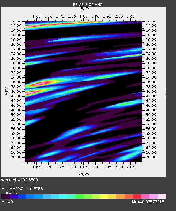
| Estimated Moho Depth: |
40.5 km |
| Estimated Crust Vp/Vs: |
1.61 |
| Assumed Crust Vp: |
5.14 km/s |
| Estimated Crust Vs: |
3.193 km/s |
| Estimated Crust Poisson's Ratio: |
0.19 |
|
| Radial Match: |
93.16589 % |
| Radial Bump: |
400 |
| Transverse Match: |
90.50643 % |
| Transverse Bump: |
400 |
| SOD ConfigId: |
21709731 |
| Insert Time: |
2020-08-05 06:36:39.196 +0000 |
| GWidth: |
2.5 |
| Max Bumps: |
400 |
| Tol: |
0.001 |
|

Signal To Noise
| Channel | StoN | STA | LTA |
| PR:CELP:00:HHZ:20200722T06:24:02.169983Z | 20.789627 | 3.672345E-6 | 1.7664314E-7 |
| PR:CELP:00:HH1:20200722T06:24:02.169983Z | 7.5726614 | 1.2787764E-6 | 1.688675E-7 |
| PR:CELP:00:HH2:20200722T06:24:02.169983Z | 6.577813 | 7.0180687E-7 | 1.0669304E-7 |
| Arrivals |
| Ps | 4.9 SECOND |
| PpPs | 20 SECOND |
| PsPs/PpSs | 25 SECOND |


