You are here: Home > Network List > PR - Puerto Rico Seismic Network (PRSN) & Puerto Rico Strong Motion Program (PRSMP) Stations List
> Station UUPR UUPR > Earthquake Result Viewer
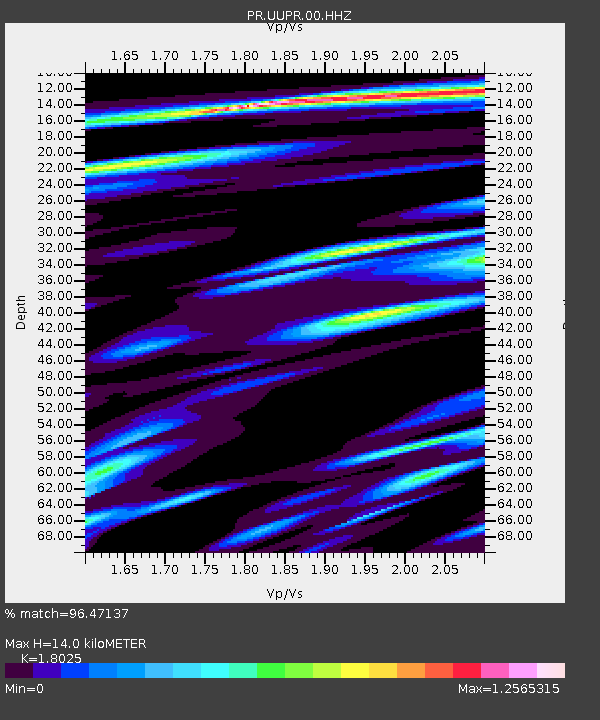
UUPR UUPR - Earthquake Result Viewer
| Earthquake location: |
Alaska Peninsula |
| Earthquake latitude/longitude: |
55.2/-158.6 |
| Earthquake time(UTC): |
2020/07/22 (204) 06:12:44 GMT |
| Earthquake Depth: |
13 km |
| Earthquake Magnitude: |
7.4 Mi |
| Earthquake Catalog/Contributor: |
NEIC PDE/at |
|
| Network: |
PR Puerto Rico Seismic Network (PRSN) & Puerto Rico Strong Motion Program (PRSMP) |
| Station: |
UUPR UUPR |
| Lat/Lon: |
18.25 N/66.72 W |
| Elevation: |
203 m |
|
| Distance: |
76.3 deg |
| Az: |
77.886 deg |
| Baz: |
323.875 deg |
| Ray Param: |
0.05110763 |
| Estimated Moho Depth: |
14.0 km |
| Estimated Crust Vp/Vs: |
1.80 |
| Assumed Crust Vp: |
5.14 km/s |
| Estimated Crust Vs: |
2.852 km/s |
| Estimated Crust Poisson's Ratio: |
0.28 |
|
| Radial Match: |
96.47137 % |
| Radial Bump: |
399 |
| Transverse Match: |
87.76745 % |
| Transverse Bump: |
400 |
| SOD ConfigId: |
21709731 |
| Insert Time: |
2020-08-05 06:36:57.780 +0000 |
| GWidth: |
2.5 |
| Max Bumps: |
400 |
| Tol: |
0.001 |
|

Signal To Noise
| Channel | StoN | STA | LTA |
| PR:UUPR:00:HHZ:20200722T06:24:00.909973Z | 30.479658 | 3.3883198E-6 | 1.11166585E-7 |
| PR:UUPR:00:HH1:20200722T06:24:00.909973Z | 7.445708 | 1.3505563E-6 | 1.8138722E-7 |
| PR:UUPR:00:HH2:20200722T06:24:00.909973Z | 4.0878444 | 4.906227E-7 | 1.200199E-7 |
| Arrivals |
| Ps | 2.2 SECOND |
| PpPs | 7.5 SECOND |
| PsPs/PpSs | 9.7 SECOND |


