You are here: Home > Network List > PY - PFO Array Stations List
> Station BPH04 Pinon Flat Observatory, CA, USA > Earthquake Result Viewer
BPH04 Pinon Flat Observatory, CA, USA - Earthquake Result Viewer
| Earthquake location: |
Alaska Peninsula |
| Earthquake latitude/longitude: |
55.2/-158.6 |
| Earthquake time(UTC): |
2020/07/22 (204) 06:12:44 GMT |
| Earthquake Depth: |
13 km |
| Earthquake Magnitude: |
7.4 Mi |
| Earthquake Catalog/Contributor: |
NEIC PDE/at |
|
| Network: |
PY PFO Array |
| Station: |
BPH04 Pinon Flat Observatory, CA, USA |
| Lat/Lon: |
33.61 N/116.46 W |
| Elevation: |
1287 m |
|
| Distance: |
36.3 deg |
| Az: |
108.877 deg |
| Baz: |
319.481 deg |
| Ray Param: |
0.07678957 |
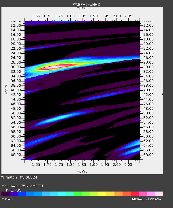
| Estimated Moho Depth: |
29.75 km |
| Estimated Crust Vp/Vs: |
1.74 |
| Assumed Crust Vp: |
6.264 km/s |
| Estimated Crust Vs: |
3.61 km/s |
| Estimated Crust Poisson's Ratio: |
0.25 |
|
| Radial Match: |
95.68524 % |
| Radial Bump: |
307 |
| Transverse Match: |
89.15009 % |
| Transverse Bump: |
400 |
| SOD ConfigId: |
21709731 |
| Insert Time: |
2020-08-05 06:37:12.205 +0000 |
| GWidth: |
2.5 |
| Max Bumps: |
400 |
| Tol: |
0.001 |
|

Signal To Noise
| Channel | StoN | STA | LTA |
| PY:BPH04: :HHZ:20200722T06:19:16.186005Z | 17.16024 | 3.6955933E-6 | 2.153579E-7 |
| PY:BPH04: :HHN:20200722T06:19:16.186005Z | 15.355935 | 1.9634736E-6 | 1.2786415E-7 |
| PY:BPH04: :HHE:20200722T06:19:16.186005Z | 10.764378 | 1.3542417E-6 | 1.2580772E-7 |
| Arrivals |
| Ps | 3.8 SECOND |
| PpPs | 12 SECOND |
| PsPs/PpSs | 16 SECOND |


