You are here: Home > Network List > SV - Servicio Nacional de Estudios Territoriales (SNET), El Salvador Stations List
> Station JAYA Z > Earthquake Result Viewer
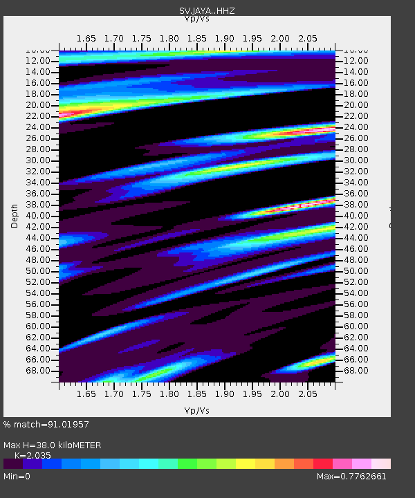
JAYA Z - Earthquake Result Viewer
| Earthquake location: |
Alaska Peninsula |
| Earthquake latitude/longitude: |
55.2/-158.6 |
| Earthquake time(UTC): |
2020/07/22 (204) 06:12:44 GMT |
| Earthquake Depth: |
13 km |
| Earthquake Magnitude: |
7.4 Mi |
| Earthquake Catalog/Contributor: |
NEIC PDE/at |
|
| Network: |
SV Servicio Nacional de Estudios Territoriales (SNET), El Salvador |
| Station: |
JAYA Z |
| Lat/Lon: |
13.65 N/89.45 W |
| Elevation: |
0.0 m |
|
| Distance: |
67.0 deg |
| Az: |
99.328 deg |
| Baz: |
324.432 deg |
| Ray Param: |
0.057228673 |
| Estimated Moho Depth: |
38.0 km |
| Estimated Crust Vp/Vs: |
2.04 |
| Assumed Crust Vp: |
6.048 km/s |
| Estimated Crust Vs: |
2.972 km/s |
| Estimated Crust Poisson's Ratio: |
0.34 |
|
| Radial Match: |
91.01957 % |
| Radial Bump: |
400 |
| Transverse Match: |
86.78802 % |
| Transverse Bump: |
400 |
| SOD ConfigId: |
21709731 |
| Insert Time: |
2020-08-05 06:38:09.273 +0000 |
| GWidth: |
2.5 |
| Max Bumps: |
400 |
| Tol: |
0.001 |
|

Signal To Noise
| Channel | StoN | STA | LTA |
| SV:JAYA: :HHZ:20200722T06:23:05.320007Z | 2.2510056 | 7.839769E-7 | 3.4827852E-7 |
| SV:JAYA: :HHN:20200722T06:23:05.320007Z | 1.2931347 | 4.7450163E-7 | 3.6693908E-7 |
| SV:JAYA: :HHE:20200722T06:23:05.320007Z | 1.6489118 | 5.489147E-7 | 3.3289515E-7 |
| Arrivals |
| Ps | 6.7 SECOND |
| PpPs | 18 SECOND |
| PsPs/PpSs | 25 SECOND |


