You are here: Home > Network List > TA - USArray Transportable Network (new EarthScope stations) Stations List
> Station M65A Busby, Falmouth, MA, USA > Earthquake Result Viewer
M65A Busby, Falmouth, MA, USA - Earthquake Result Viewer
| Earthquake location: |
Alaska Peninsula |
| Earthquake latitude/longitude: |
55.2/-158.6 |
| Earthquake time(UTC): |
2020/07/22 (204) 06:12:44 GMT |
| Earthquake Depth: |
13 km |
| Earthquake Magnitude: |
7.4 Mi |
| Earthquake Catalog/Contributor: |
NEIC PDE/at |
|
| Network: |
TA USArray Transportable Network (new EarthScope stations) |
| Station: |
M65A Busby, Falmouth, MA, USA |
| Lat/Lon: |
41.56 N/70.65 W |
| Elevation: |
22 m |
|
| Distance: |
56.1 deg |
| Az: |
64.564 deg |
| Baz: |
316.406 deg |
| Ray Param: |
0.064335585 |
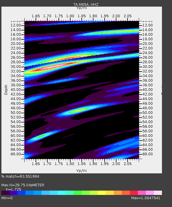
| Estimated Moho Depth: |
29.75 km |
| Estimated Crust Vp/Vs: |
1.73 |
| Assumed Crust Vp: |
6.472 km/s |
| Estimated Crust Vs: |
3.752 km/s |
| Estimated Crust Poisson's Ratio: |
0.25 |
|
| Radial Match: |
93.551994 % |
| Radial Bump: |
400 |
| Transverse Match: |
71.324745 % |
| Transverse Bump: |
400 |
| SOD ConfigId: |
21709731 |
| Insert Time: |
2020-08-05 06:38:19.459 +0000 |
| GWidth: |
2.5 |
| Max Bumps: |
400 |
| Tol: |
0.001 |
|

Signal To Noise
| Channel | StoN | STA | LTA |
| TA:M65A: :HHZ:20200722T06:21:52.119995Z | 16.618458 | 4.3959544E-6 | 2.645224E-7 |
| TA:M65A: :HHN:20200722T06:21:52.119995Z | 6.5071054 | 1.7536973E-6 | 2.69505E-7 |
| TA:M65A: :HHE:20200722T06:21:52.119995Z | 5.761318 | 1.76928E-6 | 3.0709637E-7 |
| Arrivals |
| Ps | 3.5 SECOND |
| PpPs | 12 SECOND |
| PsPs/PpSs | 15 SECOND |


