You are here: Home > Network List > TJ - Tajikistan National Seismic Network Stations List
> Station CHRDR Chorukh Dayron, Tajikistan > Earthquake Result Viewer
CHRDR Chorukh Dayron, Tajikistan - Earthquake Result Viewer
| Earthquake location: |
Alaska Peninsula |
| Earthquake latitude/longitude: |
55.2/-158.6 |
| Earthquake time(UTC): |
2020/07/22 (204) 06:12:44 GMT |
| Earthquake Depth: |
13 km |
| Earthquake Magnitude: |
7.4 Mi |
| Earthquake Catalog/Contributor: |
NEIC PDE/at |
|
| Network: |
TJ Tajikistan National Seismic Network |
| Station: |
CHRDR Chorukh Dayron, Tajikistan |
| Lat/Lon: |
40.39 N/69.67 E |
| Elevation: |
580 m |
|
| Distance: |
76.3 deg |
| Az: |
324.07 deg |
| Baz: |
26.117 deg |
| Ray Param: |
0.05111727 |
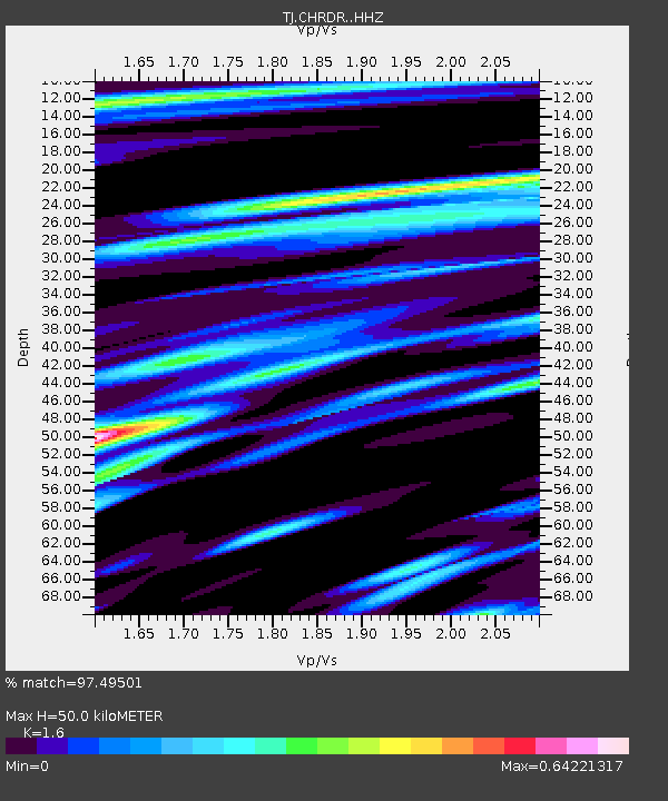
| Estimated Moho Depth: |
50.0 km |
| Estimated Crust Vp/Vs: |
1.60 |
| Assumed Crust Vp: |
6.316 km/s |
| Estimated Crust Vs: |
3.947 km/s |
| Estimated Crust Poisson's Ratio: |
0.18 |
|
| Radial Match: |
97.49501 % |
| Radial Bump: |
400 |
| Transverse Match: |
93.302376 % |
| Transverse Bump: |
400 |
| SOD ConfigId: |
21709731 |
| Insert Time: |
2020-08-05 06:38:39.892 +0000 |
| GWidth: |
2.5 |
| Max Bumps: |
400 |
| Tol: |
0.001 |
|

Signal To Noise
| Channel | StoN | STA | LTA |
| TJ:CHRDR: :HHZ:20200722T06:24:00.830017Z | 104.73155 | 1.5797834E-5 | 1.508412E-7 |
| TJ:CHRDR: :HHN:20200722T06:24:00.830017Z | 11.621957 | 5.143406E-6 | 4.4255938E-7 |
| TJ:CHRDR: :HHE:20200722T06:24:00.830017Z | 3.8899825 | 2.409154E-6 | 6.193226E-7 |
| Arrivals |
| Ps | 4.9 SECOND |
| PpPs | 20 SECOND |
| PsPs/PpSs | 25 SECOND |


