You are here: Home > Network List > TJ - Tajikistan National Seismic Network Stations List
> Station SHAA Shaartuz, Tajikistan > Earthquake Result Viewer
SHAA Shaartuz, Tajikistan - Earthquake Result Viewer
| Earthquake location: |
Alaska Peninsula |
| Earthquake latitude/longitude: |
55.2/-158.6 |
| Earthquake time(UTC): |
2020/07/22 (204) 06:12:44 GMT |
| Earthquake Depth: |
13 km |
| Earthquake Magnitude: |
7.4 Mi |
| Earthquake Catalog/Contributor: |
NEIC PDE/at |
|
| Network: |
TJ Tajikistan National Seismic Network |
| Station: |
SHAA Shaartuz, Tajikistan |
| Lat/Lon: |
37.56 N/68.12 E |
| Elevation: |
868 m |
|
| Distance: |
79.3 deg |
| Az: |
323.936 deg |
| Baz: |
25.118 deg |
| Ray Param: |
0.049041715 |
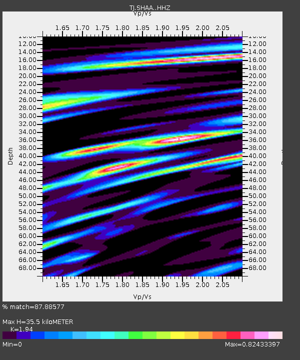
| Estimated Moho Depth: |
35.5 km |
| Estimated Crust Vp/Vs: |
1.94 |
| Assumed Crust Vp: |
6.213 km/s |
| Estimated Crust Vs: |
3.203 km/s |
| Estimated Crust Poisson's Ratio: |
0.32 |
|
| Radial Match: |
87.88577 % |
| Radial Bump: |
400 |
| Transverse Match: |
90.54641 % |
| Transverse Bump: |
400 |
| SOD ConfigId: |
21709731 |
| Insert Time: |
2020-08-05 06:38:45.772 +0000 |
| GWidth: |
2.5 |
| Max Bumps: |
400 |
| Tol: |
0.001 |
|
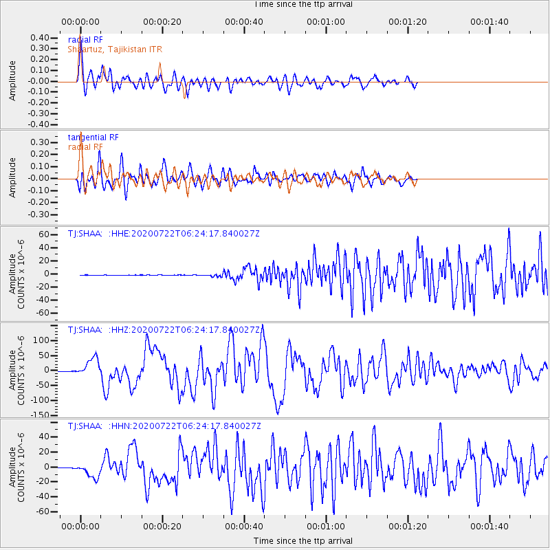
Signal To Noise
| Channel | StoN | STA | LTA |
| TJ:SHAA: :HHZ:20200722T06:24:17.840027Z | 135.93927 | 3.1676806E-5 | 2.3302177E-7 |
| TJ:SHAA: :HHN:20200722T06:24:17.840027Z | 51.53021 | 9.930533E-6 | 1.9271285E-7 |
| TJ:SHAA: :HHE:20200722T06:24:17.840027Z | 10.567293 | 1.6055934E-6 | 1.5193989E-7 |
| Arrivals |
| Ps | 5.5 SECOND |
| PpPs | 16 SECOND |
| PsPs/PpSs | 22 SECOND |


