You are here: Home > Network List > TX - Texas Seismological Network Stations List
> Station 435B Jarrell, TX, USA > Earthquake Result Viewer
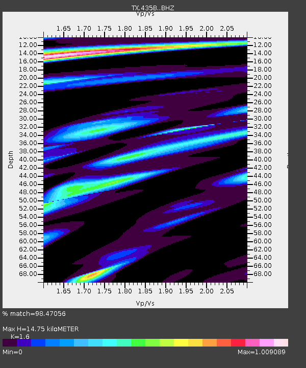
435B Jarrell, TX, USA - Earthquake Result Viewer
| Earthquake location: |
Alaska Peninsula |
| Earthquake latitude/longitude: |
55.2/-158.6 |
| Earthquake time(UTC): |
2020/07/22 (204) 06:12:44 GMT |
| Earthquake Depth: |
13 km |
| Earthquake Magnitude: |
7.4 Mi |
| Earthquake Catalog/Contributor: |
NEIC PDE/at |
|
| Network: |
TX Texas Seismological Network |
| Station: |
435B Jarrell, TX, USA |
| Lat/Lon: |
30.78 N/97.58 W |
| Elevation: |
248 m |
|
| Distance: |
49.0 deg |
| Az: |
93.803 deg |
| Baz: |
318.368 deg |
| Ray Param: |
0.06899916 |
| Estimated Moho Depth: |
14.75 km |
| Estimated Crust Vp/Vs: |
1.60 |
| Assumed Crust Vp: |
6.347 km/s |
| Estimated Crust Vs: |
3.967 km/s |
| Estimated Crust Poisson's Ratio: |
0.18 |
|
| Radial Match: |
98.47056 % |
| Radial Bump: |
330 |
| Transverse Match: |
94.22868 % |
| Transverse Bump: |
400 |
| SOD ConfigId: |
21709731 |
| Insert Time: |
2020-08-05 06:39:03.256 +0000 |
| GWidth: |
2.5 |
| Max Bumps: |
400 |
| Tol: |
0.001 |
|

Signal To Noise
| Channel | StoN | STA | LTA |
| TX:435B: :BHZ:20200722T06:20:59.123993Z | 19.858284 | 2.4629428E-6 | 1.2402596E-7 |
| TX:435B: :BHN:20200722T06:20:59.123993Z | 10.959117 | 9.76319E-7 | 8.9087386E-8 |
| TX:435B: :BHE:20200722T06:20:59.123993Z | 11.874789 | 9.0403086E-7 | 7.613027E-8 |
| Arrivals |
| Ps | 1.5 SECOND |
| PpPs | 5.7 SECOND |
| PsPs/PpSs | 7.2 SECOND |


