You are here: Home > Network List > TX - Texas Seismological Network Stations List
> Station DRZT Darrouzett > Earthquake Result Viewer
DRZT Darrouzett - Earthquake Result Viewer
| Earthquake location: |
Alaska Peninsula |
| Earthquake latitude/longitude: |
55.2/-158.6 |
| Earthquake time(UTC): |
2020/07/22 (204) 06:12:44 GMT |
| Earthquake Depth: |
13 km |
| Earthquake Magnitude: |
7.4 Mi |
| Earthquake Catalog/Contributor: |
NEIC PDE/at |
|
| Network: |
TX Texas Seismological Network |
| Station: |
DRZT Darrouzett |
| Lat/Lon: |
36.44 N/100.30 W |
| Elevation: |
791 m |
|
| Distance: |
43.3 deg |
| Az: |
90.699 deg |
| Baz: |
314.718 deg |
| Ray Param: |
0.07262273 |
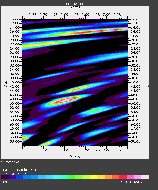
| Estimated Moho Depth: |
48.25 km |
| Estimated Crust Vp/Vs: |
1.81 |
| Assumed Crust Vp: |
6.483 km/s |
| Estimated Crust Vs: |
3.591 km/s |
| Estimated Crust Poisson's Ratio: |
0.28 |
|
| Radial Match: |
95.1657 % |
| Radial Bump: |
400 |
| Transverse Match: |
83.60693 % |
| Transverse Bump: |
400 |
| SOD ConfigId: |
21709731 |
| Insert Time: |
2020-08-05 06:39:12.297 +0000 |
| GWidth: |
2.5 |
| Max Bumps: |
400 |
| Tol: |
0.001 |
|

Signal To Noise
| Channel | StoN | STA | LTA |
| TX:DRZT:00:HHZ:20200722T06:20:14.640015Z | 16.314705 | 2.30691E-6 | 1.4140065E-7 |
| TX:DRZT:00:HH1:20200722T06:20:14.640015Z | 7.0147686 | 1.0282188E-6 | 1.4657914E-7 |
| TX:DRZT:00:HH2:20200722T06:20:14.640015Z | 5.420219 | 9.336342E-7 | 1.7225028E-7 |
| Arrivals |
| Ps | 6.4 SECOND |
| PpPs | 20 SECOND |
| PsPs/PpSs | 26 SECOND |


