You are here: Home > Network List > TX - Texas Seismological Network Stations List
> Station FW12 Venus > Earthquake Result Viewer
FW12 Venus - Earthquake Result Viewer
| Earthquake location: |
Alaska Peninsula |
| Earthquake latitude/longitude: |
55.2/-158.6 |
| Earthquake time(UTC): |
2020/07/22 (204) 06:12:44 GMT |
| Earthquake Depth: |
13 km |
| Earthquake Magnitude: |
7.4 Mi |
| Earthquake Catalog/Contributor: |
NEIC PDE/at |
|
| Network: |
TX Texas Seismological Network |
| Station: |
FW12 Venus |
| Lat/Lon: |
32.50 N/97.15 W |
| Elevation: |
204 m |
|
| Distance: |
48.0 deg |
| Az: |
91.901 deg |
| Baz: |
317.334 deg |
| Ray Param: |
0.06967151 |
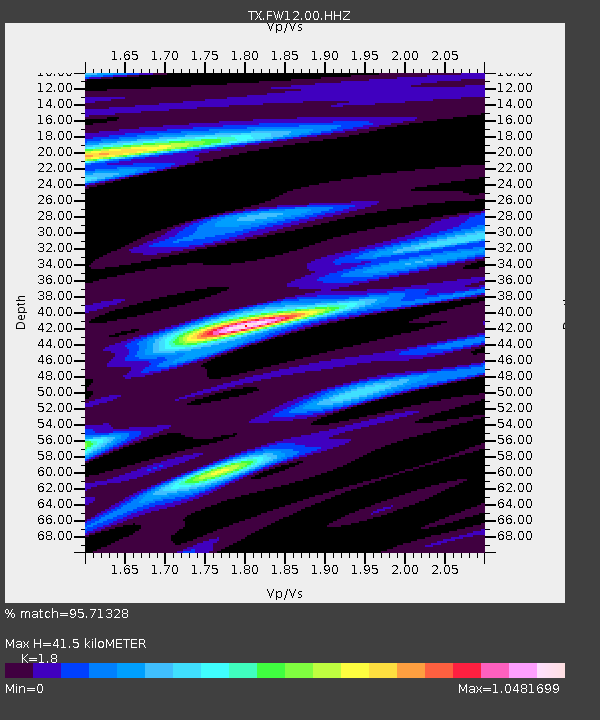
| Estimated Moho Depth: |
41.5 km |
| Estimated Crust Vp/Vs: |
1.80 |
| Assumed Crust Vp: |
6.38 km/s |
| Estimated Crust Vs: |
3.545 km/s |
| Estimated Crust Poisson's Ratio: |
0.28 |
|
| Radial Match: |
95.71328 % |
| Radial Bump: |
322 |
| Transverse Match: |
94.63493 % |
| Transverse Bump: |
388 |
| SOD ConfigId: |
21709731 |
| Insert Time: |
2020-08-05 06:39:30.528 +0000 |
| GWidth: |
2.5 |
| Max Bumps: |
400 |
| Tol: |
0.001 |
|
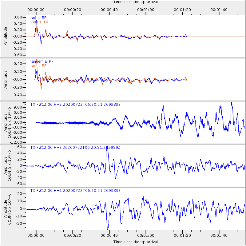
Signal To Noise
| Channel | StoN | STA | LTA |
| TX:FW12:00:HHZ:20200722T06:20:51.269989Z | 17.37306 | 2.5203765E-6 | 1.4507383E-7 |
| TX:FW12:00:HH1:20200722T06:20:51.269989Z | 8.756505 | 1.1762514E-6 | 1.3432887E-7 |
| TX:FW12:00:HH2:20200722T06:20:51.269989Z | 2.0806937 | 6.093774E-7 | 2.9287224E-7 |
| Arrivals |
| Ps | 5.5 SECOND |
| PpPs | 17 SECOND |
| PsPs/PpSs | 23 SECOND |


