You are here: Home > Network List > TX - Texas Seismological Network Stations List
> Station PB30 Pecos City Water South > Earthquake Result Viewer
PB30 Pecos City Water South - Earthquake Result Viewer
| Earthquake location: |
Alaska Peninsula |
| Earthquake latitude/longitude: |
55.2/-158.6 |
| Earthquake time(UTC): |
2020/07/22 (204) 06:12:44 GMT |
| Earthquake Depth: |
13 km |
| Earthquake Magnitude: |
7.4 Mi |
| Earthquake Catalog/Contributor: |
NEIC PDE/at |
|
| Network: |
TX Texas Seismological Network |
| Station: |
PB30 Pecos City Water South |
| Lat/Lon: |
31.28 N/103.32 W |
| Elevation: |
829 m |
|
| Distance: |
45.3 deg |
| Az: |
98.382 deg |
| Baz: |
318.538 deg |
| Ray Param: |
0.07134411 |
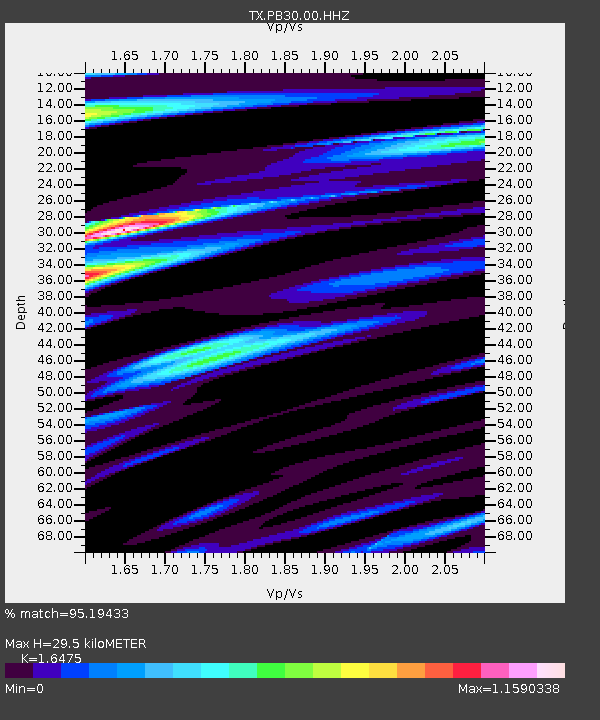
| Estimated Moho Depth: |
29.5 km |
| Estimated Crust Vp/Vs: |
1.65 |
| Assumed Crust Vp: |
6.121 km/s |
| Estimated Crust Vs: |
3.715 km/s |
| Estimated Crust Poisson's Ratio: |
0.21 |
|
| Radial Match: |
95.19433 % |
| Radial Bump: |
400 |
| Transverse Match: |
90.65615 % |
| Transverse Bump: |
400 |
| SOD ConfigId: |
21709731 |
| Insert Time: |
2020-08-05 06:40:20.238 +0000 |
| GWidth: |
2.5 |
| Max Bumps: |
400 |
| Tol: |
0.001 |
|

Signal To Noise
| Channel | StoN | STA | LTA |
| TX:PB30:00:HHZ:20200722T06:20:30.76001Z | 10.078484 | 2.4364942E-6 | 2.4175208E-7 |
| TX:PB30:00:HH1:20200722T06:20:30.76001Z | 8.502658 | 8.3147995E-7 | 9.77906E-8 |
| TX:PB30:00:HH2:20200722T06:20:30.76001Z | 4.1240067 | 5.862724E-7 | 1.4216087E-7 |
| Arrivals |
| Ps | 3.3 SECOND |
| PpPs | 12 SECOND |
| PsPs/PpSs | 15 SECOND |


