You are here: Home > Network List > TX - Texas Seismological Network Stations List
> Station PH03 Pantex > Earthquake Result Viewer
PH03 Pantex - Earthquake Result Viewer
| Earthquake location: |
Alaska Peninsula |
| Earthquake latitude/longitude: |
55.2/-158.6 |
| Earthquake time(UTC): |
2020/07/22 (204) 06:12:44 GMT |
| Earthquake Depth: |
13 km |
| Earthquake Magnitude: |
7.4 Mi |
| Earthquake Catalog/Contributor: |
NEIC PDE/at |
|
| Network: |
TX Texas Seismological Network |
| Station: |
PH03 Pantex |
| Lat/Lon: |
35.36 N/101.55 W |
| Elevation: |
1061 m |
|
| Distance: |
43.4 deg |
| Az: |
92.865 deg |
| Baz: |
315.561 deg |
| Ray Param: |
0.0725902 |
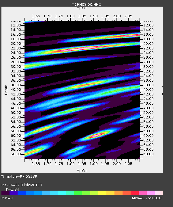
| Estimated Moho Depth: |
22.0 km |
| Estimated Crust Vp/Vs: |
1.84 |
| Assumed Crust Vp: |
6.426 km/s |
| Estimated Crust Vs: |
3.492 km/s |
| Estimated Crust Poisson's Ratio: |
0.29 |
|
| Radial Match: |
97.03139 % |
| Radial Bump: |
400 |
| Transverse Match: |
88.01824 % |
| Transverse Bump: |
400 |
| SOD ConfigId: |
21709731 |
| Insert Time: |
2020-08-05 06:40:23.430 +0000 |
| GWidth: |
2.5 |
| Max Bumps: |
400 |
| Tol: |
0.001 |
|

Signal To Noise
| Channel | StoN | STA | LTA |
| TX:PH03:00:HHZ:20200722T06:20:15.049988Z | 2.9754736 | 2.0241953E-6 | 6.802934E-7 |
| TX:PH03:00:HH1:20200722T06:20:15.049988Z | 1.6201843 | 1.1983977E-6 | 7.3966754E-7 |
| TX:PH03:00:HH2:20200722T06:20:15.049988Z | 1.1535368 | 1.0237558E-6 | 8.8749294E-7 |
| Arrivals |
| Ps | 3.1 SECOND |
| PpPs | 9.1 SECOND |
| PsPs/PpSs | 12 SECOND |


