You are here: Home > Network List > TX - Texas Seismological Network Stations List
> Station SAND Sanderson > Earthquake Result Viewer
SAND Sanderson - Earthquake Result Viewer
| Earthquake location: |
Alaska Peninsula |
| Earthquake latitude/longitude: |
55.2/-158.6 |
| Earthquake time(UTC): |
2020/07/22 (204) 06:12:44 GMT |
| Earthquake Depth: |
13 km |
| Earthquake Magnitude: |
7.4 Mi |
| Earthquake Catalog/Contributor: |
NEIC PDE/at |
|
| Network: |
TX Texas Seismological Network |
| Station: |
SAND Sanderson |
| Lat/Lon: |
29.95 N/102.12 W |
| Elevation: |
689 m |
|
| Distance: |
47.0 deg |
| Az: |
98.506 deg |
| Baz: |
319.232 deg |
| Ray Param: |
0.0702728 |
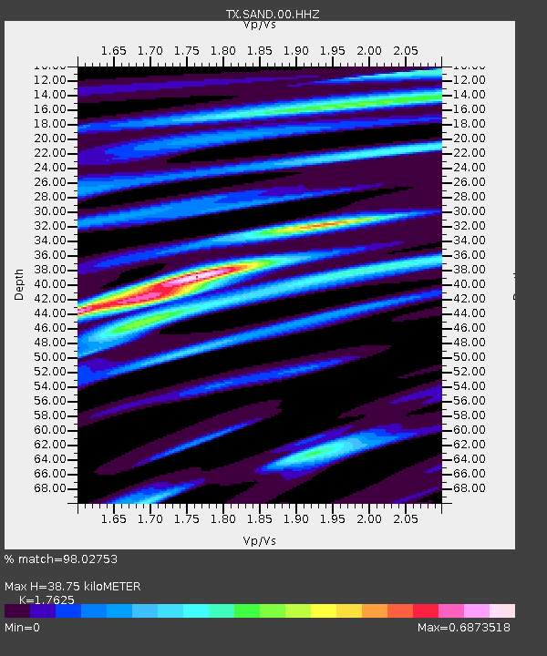
| Estimated Moho Depth: |
38.75 km |
| Estimated Crust Vp/Vs: |
1.76 |
| Assumed Crust Vp: |
6.419 km/s |
| Estimated Crust Vs: |
3.642 km/s |
| Estimated Crust Poisson's Ratio: |
0.26 |
|
| Radial Match: |
98.02753 % |
| Radial Bump: |
285 |
| Transverse Match: |
91.37824 % |
| Transverse Bump: |
400 |
| SOD ConfigId: |
21709731 |
| Insert Time: |
2020-08-05 06:40:28.971 +0000 |
| GWidth: |
2.5 |
| Max Bumps: |
400 |
| Tol: |
0.001 |
|

Signal To Noise
| Channel | StoN | STA | LTA |
| TX:SAND:00:HHZ:20200722T06:20:43.929993Z | 24.267424 | 2.2265328E-6 | 9.174987E-8 |
| TX:SAND:00:HH1:20200722T06:20:43.929993Z | 3.4807777 | 1.6438302E-7 | 4.722595E-8 |
| TX:SAND:00:HH2:20200722T06:20:43.929993Z | 16.599848 | 1.1273185E-6 | 6.791138E-8 |
| Arrivals |
| Ps | 4.9 SECOND |
| PpPs | 16 SECOND |
| PsPs/PpSs | 21 SECOND |


