You are here: Home > Network List > NE - New England Seismic Network Stations List
> Station PQI Presque Isle, ME, USA > Earthquake Result Viewer
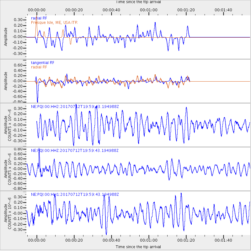
PQI Presque Isle, ME, USA - Earthquake Result Viewer
*The percent match for this event was below the threshold and hence no stack was calculated.
| Earthquake location: |
Sea Of Japan |
| Earthquake latitude/longitude: |
40.9/131.6 |
| Earthquake time(UTC): |
2017/07/12 (193) 19:48:07 GMT |
| Earthquake Depth: |
538 km |
| Earthquake Magnitude: |
5.8 Mww |
| Earthquake Catalog/Contributor: |
NEIC PDE/us |
|
| Network: |
NE New England Seismic Network |
| Station: |
PQI Presque Isle, ME, USA |
| Lat/Lon: |
46.67 N/68.02 W |
| Elevation: |
162 m |
|
| Distance: |
91.1 deg |
| Az: |
13.394 deg |
| Baz: |
345.217 deg |
| Ray Param: |
$rayparam |
*The percent match for this event was below the threshold and hence was not used in the summary stack. |
|
| Radial Match: |
52.596752 % |
| Radial Bump: |
400 |
| Transverse Match: |
65.04001 % |
| Transverse Bump: |
400 |
| SOD ConfigId: |
2140511 |
| Insert Time: |
2017-07-26 11:48:03.002 +0000 |
| GWidth: |
2.5 |
| Max Bumps: |
400 |
| Tol: |
0.001 |
|
Signal To Noise
| Channel | StoN | STA | LTA |
| NE:PQI:00:HHZ:20170712T19:59:43.194988Z | 1.7617962 | 2.5883423E-7 | 1.4691497E-7 |
| NE:PQI:00:HH1:20170712T19:59:43.194988Z | 0.9812751 | 1.4478805E-7 | 1.4755092E-7 |
| NE:PQI:00:HH2:20170712T19:59:43.194988Z | 1.5699116 | 2.432998E-7 | 1.5497676E-7 |
| Arrivals |
| Ps | |
| PpPs | |
| PsPs/PpSs | |


