You are here: Home > Network List > US - United States National Seismic Network Stations List
> Station AMTX Amarillo, Texas, USA > Earthquake Result Viewer
AMTX Amarillo, Texas, USA - Earthquake Result Viewer
*The percent match for this event was below the threshold and hence no stack was calculated.
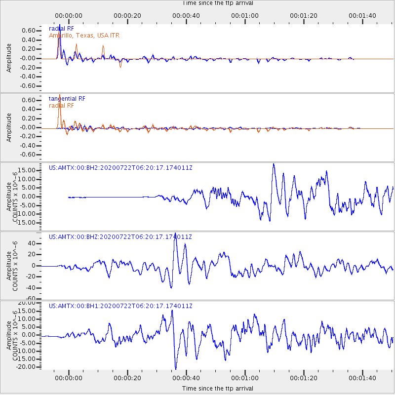
| Earthquake location: |
Alaska Peninsula |
| Earthquake latitude/longitude: |
55.2/-158.6 |
| Earthquake time(UTC): |
2020/07/22 (204) 06:12:44 GMT |
| Earthquake Depth: |
13 km |
| Earthquake Magnitude: |
7.4 Mi |
| Earthquake Catalog/Contributor: |
NEIC PDE/at |
|
| Network: |
US United States National Seismic Network |
| Station: |
AMTX Amarillo, Texas, USA |
| Lat/Lon: |
34.53 N/101.41 W |
| Elevation: |
1010 m |
|
| Distance: |
44.0 deg |
| Az: |
93.575 deg |
| Baz: |
316.155 deg |
| Ray Param: |
$rayparam |
*The percent match for this event was below the threshold and hence was not used in the summary stack. |
|
| Radial Match: |
98.80916 % |
| Radial Bump: |
251 |
| Transverse Match: |
91.08807 % |
| Transverse Bump: |
400 |
| SOD ConfigId: |
21709731 |
| Insert Time: |
2020-08-05 06:40:54.815 +0000 |
| GWidth: |
2.5 |
| Max Bumps: |
400 |
| Tol: |
0.001 |
|
Signal To Noise
| Channel | StoN | STA | LTA |
| US:AMTX:00:BHZ:20200722T06:20:17.174011Z | 21.802439 | 3.2658975E-6 | 1.4979506E-7 |
| US:AMTX:00:BH1:20200722T06:20:17.174011Z | 17.203152 | 1.2393649E-6 | 7.2042894E-8 |
| US:AMTX:00:BH2:20200722T06:20:17.174011Z | 14.905506 | 1.3169863E-6 | 8.835569E-8 |
| Arrivals |
| Ps | |
| PpPs | |
| PsPs/PpSs | |


