You are here: Home > Network List > US - United States National Seismic Network Stations List
> Station BOZ Bozeman, Montana, USA > Earthquake Result Viewer
BOZ Bozeman, Montana, USA - Earthquake Result Viewer

| Earthquake location: |
Alaska Peninsula |
| Earthquake latitude/longitude: |
55.2/-158.6 |
| Earthquake time(UTC): |
2020/07/22 (204) 06:12:44 GMT |
| Earthquake Depth: |
13 km |
| Earthquake Magnitude: |
7.4 Mi |
| Earthquake Catalog/Contributor: |
NEIC PDE/at |
|
| Network: |
US United States National Seismic Network |
| Station: |
BOZ Bozeman, Montana, USA |
| Lat/Lon: |
45.65 N/111.63 W |
| Elevation: |
1589 m |
|
| Distance: |
30.9 deg |
| Az: |
88.207 deg |
| Baz: |
305.267 deg |
| Ray Param: |
0.07928032 |
| Estimated Moho Depth: |
25.25 km |
| Estimated Crust Vp/Vs: |
2.10 |
| Assumed Crust Vp: |
6.35 km/s |
| Estimated Crust Vs: |
3.031 km/s |
| Estimated Crust Poisson's Ratio: |
0.35 |
|
| Radial Match: |
96.55102 % |
| Radial Bump: |
362 |
| Transverse Match: |
91.806206 % |
| Transverse Bump: |
400 |
| SOD ConfigId: |
21709731 |
| Insert Time: |
2020-08-05 06:40:58.851 +0000 |
| GWidth: |
2.5 |
| Max Bumps: |
400 |
| Tol: |
0.001 |
|
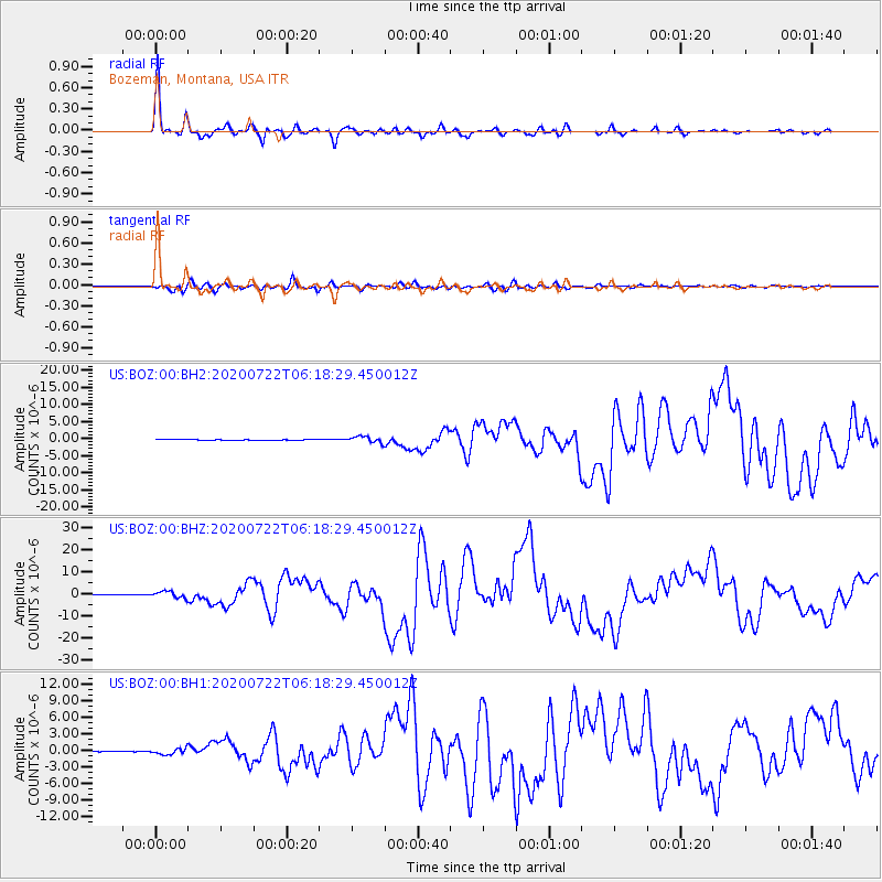
Signal To Noise
| Channel | StoN | STA | LTA |
| US:BOZ:00:BHZ:20200722T06:18:29.450012Z | 17.02538 | 1.4949497E-6 | 8.780714E-8 |
| US:BOZ:00:BH1:20200722T06:18:29.450012Z | 8.512757 | 5.595078E-7 | 6.57258E-8 |
| US:BOZ:00:BH2:20200722T06:18:29.450012Z | 10.380792 | 8.072611E-7 | 7.776488E-8 |
| Arrivals |
| Ps | 4.7 SECOND |
| PpPs | 12 SECOND |
| PsPs/PpSs | 16 SECOND |


