You are here: Home > Network List > US - United States National Seismic Network Stations List
> Station SDCO Great Sand Dunes National Park, Colorado, USA > Earthquake Result Viewer
SDCO Great Sand Dunes National Park, Colorado, USA - Earthquake Result Viewer
| Earthquake location: |
Alaska Peninsula |
| Earthquake latitude/longitude: |
55.2/-158.6 |
| Earthquake time(UTC): |
2020/07/22 (204) 06:12:44 GMT |
| Earthquake Depth: |
13 km |
| Earthquake Magnitude: |
7.4 Mi |
| Earthquake Catalog/Contributor: |
NEIC PDE/at |
|
| Network: |
US United States National Seismic Network |
| Station: |
SDCO Great Sand Dunes National Park, Colorado, USA |
| Lat/Lon: |
37.75 N/105.50 W |
| Elevation: |
2569 m |
|
| Distance: |
39.4 deg |
| Az: |
93.687 deg |
| Baz: |
313.834 deg |
| Ray Param: |
0.07498971 |
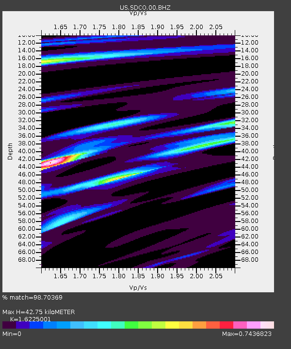
| Estimated Moho Depth: |
42.75 km |
| Estimated Crust Vp/Vs: |
1.62 |
| Assumed Crust Vp: |
6.316 km/s |
| Estimated Crust Vs: |
3.892 km/s |
| Estimated Crust Poisson's Ratio: |
0.19 |
|
| Radial Match: |
98.70369 % |
| Radial Bump: |
276 |
| Transverse Match: |
95.93107 % |
| Transverse Bump: |
314 |
| SOD ConfigId: |
21709731 |
| Insert Time: |
2020-08-05 06:41:48.016 +0000 |
| GWidth: |
2.5 |
| Max Bumps: |
400 |
| Tol: |
0.001 |
|
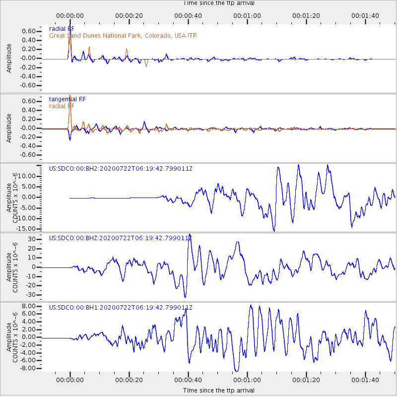
Signal To Noise
| Channel | StoN | STA | LTA |
| US:SDCO:00:BHZ:20200722T06:19:42.799011Z | 15.375647 | 1.6022207E-6 | 1.0420509E-7 |
| US:SDCO:00:BH1:20200722T06:19:42.799011Z | 11.968578 | 3.2391034E-7 | 2.7063393E-8 |
| US:SDCO:00:BH2:20200722T06:19:42.799011Z | 12.178935 | 8.391894E-7 | 6.890499E-8 |
| Arrivals |
| Ps | 4.5 SECOND |
| PpPs | 16 SECOND |
| PsPs/PpSs | 21 SECOND |


