You are here: Home > Network List > UU - University of Utah Regional Network Stations List
> Station BRWY Blue Rim, WY, USA > Earthquake Result Viewer
BRWY Blue Rim, WY, USA - Earthquake Result Viewer
| Earthquake location: |
Alaska Peninsula |
| Earthquake latitude/longitude: |
55.2/-158.6 |
| Earthquake time(UTC): |
2020/07/22 (204) 06:12:44 GMT |
| Earthquake Depth: |
13 km |
| Earthquake Magnitude: |
7.4 Mi |
| Earthquake Catalog/Contributor: |
NEIC PDE/at |
|
| Network: |
UU University of Utah Regional Network |
| Station: |
BRWY Blue Rim, WY, USA |
| Lat/Lon: |
41.62 N/109.50 W |
| Elevation: |
2098 m |
|
| Distance: |
34.5 deg |
| Az: |
92.346 deg |
| Baz: |
310.215 deg |
| Ray Param: |
0.077684484 |
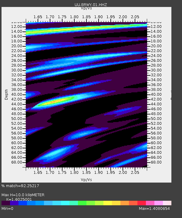
| Estimated Moho Depth: |
10.0 km |
| Estimated Crust Vp/Vs: |
1.60 |
| Assumed Crust Vp: |
6.207 km/s |
| Estimated Crust Vs: |
3.873 km/s |
| Estimated Crust Poisson's Ratio: |
0.18 |
|
| Radial Match: |
92.25217 % |
| Radial Bump: |
392 |
| Transverse Match: |
88.81999 % |
| Transverse Bump: |
400 |
| SOD ConfigId: |
21709731 |
| Insert Time: |
2020-08-05 06:41:57.021 +0000 |
| GWidth: |
2.5 |
| Max Bumps: |
400 |
| Tol: |
0.001 |
|

Signal To Noise
| Channel | StoN | STA | LTA |
| UU:BRWY:01:HHZ:20200722T06:19:01.339996Z | 21.262539 | 8.945191E-8 | 4.207019E-9 |
| UU:BRWY:01:HHN:20200722T06:19:01.339996Z | 5.808157 | 1.9806363E-8 | 3.4100942E-9 |
| UU:BRWY:01:HHE:20200722T06:19:01.339996Z | 10.170657 | 2.9077205E-8 | 2.8589309E-9 |
| Arrivals |
| Ps | 1.1 SECOND |
| PpPs | 3.9 SECOND |
| PsPs/PpSs | 4.9 SECOND |


