You are here: Home > Network List > UU - University of Utah Regional Network Stations List
> Station LIUT Lila Canyon, UT, USA > Earthquake Result Viewer
LIUT Lila Canyon, UT, USA - Earthquake Result Viewer
| Earthquake location: |
Alaska Peninsula |
| Earthquake latitude/longitude: |
55.2/-158.6 |
| Earthquake time(UTC): |
2020/07/22 (204) 06:12:44 GMT |
| Earthquake Depth: |
13 km |
| Earthquake Magnitude: |
7.4 Mi |
| Earthquake Catalog/Contributor: |
NEIC PDE/at |
|
| Network: |
UU University of Utah Regional Network |
| Station: |
LIUT Lila Canyon, UT, USA |
| Lat/Lon: |
39.42 N/110.33 W |
| Elevation: |
2178 m |
|
| Distance: |
35.5 deg |
| Az: |
95.936 deg |
| Baz: |
312.623 deg |
| Ray Param: |
0.0771679 |
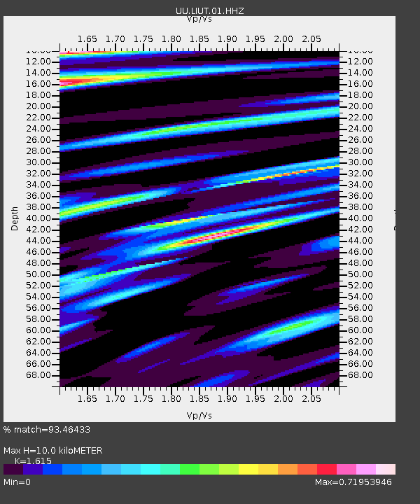
| Estimated Moho Depth: |
10.0 km |
| Estimated Crust Vp/Vs: |
1.62 |
| Assumed Crust Vp: |
6.207 km/s |
| Estimated Crust Vs: |
3.843 km/s |
| Estimated Crust Poisson's Ratio: |
0.19 |
|
| Radial Match: |
93.46433 % |
| Radial Bump: |
400 |
| Transverse Match: |
84.3532 % |
| Transverse Bump: |
400 |
| SOD ConfigId: |
21709731 |
| Insert Time: |
2020-08-05 06:42:20.350 +0000 |
| GWidth: |
2.5 |
| Max Bumps: |
400 |
| Tol: |
0.001 |
|

Signal To Noise
| Channel | StoN | STA | LTA |
| UU:LIUT:01:HHZ:20200722T06:19:09.790009Z | 15.145707 | 7.7118585E-8 | 5.0917786E-9 |
| UU:LIUT:01:HHN:20200722T06:19:09.790009Z | 10.070193 | 2.4528823E-8 | 2.435785E-9 |
| UU:LIUT:01:HHE:20200722T06:19:09.790009Z | 8.598897 | 3.44536E-8 | 4.0067465E-9 |
| Arrivals |
| Ps | 1.1 SECOND |
| PpPs | 3.9 SECOND |
| PsPs/PpSs | 5.0 SECOND |


