You are here: Home > Network List > UU - University of Utah Regional Network Stations List
> Station MTPU Mt. Pierson, UT, USA > Earthquake Result Viewer
MTPU Mt. Pierson, UT, USA - Earthquake Result Viewer
| Earthquake location: |
Alaska Peninsula |
| Earthquake latitude/longitude: |
55.2/-158.6 |
| Earthquake time(UTC): |
2020/07/22 (204) 06:12:44 GMT |
| Earthquake Depth: |
13 km |
| Earthquake Magnitude: |
7.4 Mi |
| Earthquake Catalog/Contributor: |
NEIC PDE/at |
|
| Network: |
UU University of Utah Regional Network |
| Station: |
MTPU Mt. Pierson, UT, USA |
| Lat/Lon: |
38.04 N/112.18 W |
| Elevation: |
3112 m |
|
| Distance: |
35.4 deg |
| Az: |
99.386 deg |
| Baz: |
314.274 deg |
| Ray Param: |
0.077224836 |
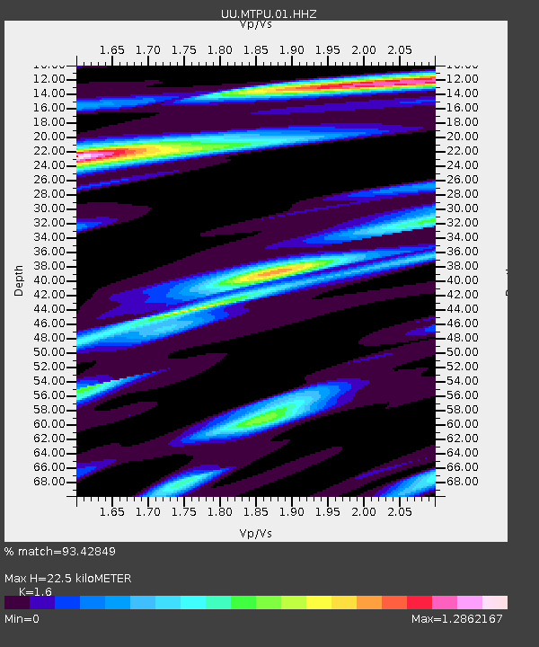
| Estimated Moho Depth: |
22.5 km |
| Estimated Crust Vp/Vs: |
1.60 |
| Assumed Crust Vp: |
6.276 km/s |
| Estimated Crust Vs: |
3.922 km/s |
| Estimated Crust Poisson's Ratio: |
0.18 |
|
| Radial Match: |
93.42849 % |
| Radial Bump: |
286 |
| Transverse Match: |
84.281845 % |
| Transverse Bump: |
313 |
| SOD ConfigId: |
21709731 |
| Insert Time: |
2020-08-05 06:42:23.046 +0000 |
| GWidth: |
2.5 |
| Max Bumps: |
400 |
| Tol: |
0.001 |
|

Signal To Noise
| Channel | StoN | STA | LTA |
| UU:MTPU:01:HHZ:20200722T06:19:08.877991Z | 14.448067 | 8.1258726E-8 | 5.6241936E-9 |
| UU:MTPU:01:HHN:20200722T06:19:08.877991Z | 11.167657 | 2.7109474E-8 | 2.4274986E-9 |
| UU:MTPU:01:HHE:20200722T06:19:08.877991Z | 11.2841625 | 3.150881E-8 | 2.792304E-9 |
| Arrivals |
| Ps | 2.3 SECOND |
| PpPs | 8.6 SECOND |
| PsPs/PpSs | 11 SECOND |


