You are here: Home > Network List > YX16 - Raton Basin UNM Broadband Network Stations List
> Station UNM2 SE Corner of NM Stations > Earthquake Result Viewer
UNM2 SE Corner of NM Stations - Earthquake Result Viewer
| Earthquake location: |
Alaska Peninsula |
| Earthquake latitude/longitude: |
55.2/-158.6 |
| Earthquake time(UTC): |
2020/07/22 (204) 06:12:44 GMT |
| Earthquake Depth: |
13 km |
| Earthquake Magnitude: |
7.4 Mi |
| Earthquake Catalog/Contributor: |
NEIC PDE/at |
|
| Network: |
YX Raton Basin UNM Broadband Network |
| Station: |
UNM2 SE Corner of NM Stations |
| Lat/Lon: |
36.80 N/104.86 W |
| Elevation: |
2166 m |
|
| Distance: |
40.5 deg |
| Az: |
94.186 deg |
| Baz: |
314.601 deg |
| Ray Param: |
0.07438586 |
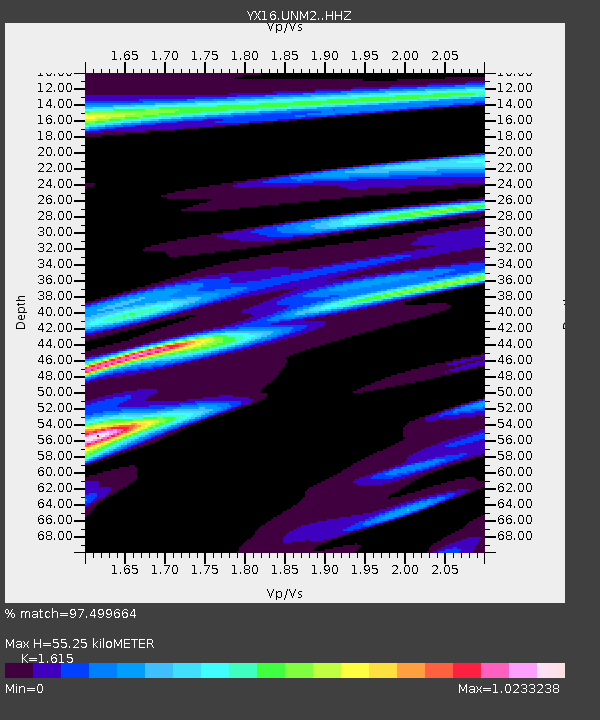
| Estimated Moho Depth: |
55.25 km |
| Estimated Crust Vp/Vs: |
1.62 |
| Assumed Crust Vp: |
6.316 km/s |
| Estimated Crust Vs: |
3.911 km/s |
| Estimated Crust Poisson's Ratio: |
0.19 |
|
| Radial Match: |
97.499664 % |
| Radial Bump: |
400 |
| Transverse Match: |
96.300705 % |
| Transverse Bump: |
400 |
| SOD ConfigId: |
21709731 |
| Insert Time: |
2020-08-05 06:44:52.374 +0000 |
| GWidth: |
2.5 |
| Max Bumps: |
400 |
| Tol: |
0.001 |
|

Signal To Noise
| Channel | StoN | STA | LTA |
| YX:UNM2: :HHZ:20200722T06:19:51.259003Z | 11.010196 | 1.7455432E-6 | 1.585388E-7 |
| YX:UNM2: :HHN:20200722T06:19:51.259003Z | 7.6633725 | 7.327896E-7 | 9.562234E-8 |
| YX:UNM2: :HHE:20200722T06:19:51.259003Z | 7.5171766 | 7.0691283E-7 | 9.403967E-8 |
| Arrivals |
| Ps | 5.8 SECOND |
| PpPs | 21 SECOND |
| PsPs/PpSs | 27 SECOND |


