You are here: Home > Network List > CA - Catalan Seismic Network Stations List
> Station CFON Fontmartina > Earthquake Result Viewer
CFON Fontmartina - Earthquake Result Viewer

| Earthquake location: |
South Of Alaska |
| Earthquake latitude/longitude: |
54.9/-159.0 |
| Earthquake time(UTC): |
2020/07/22 (204) 06:16:18 GMT |
| Earthquake Depth: |
18 km |
| Earthquake Magnitude: |
6.1 mb |
| Earthquake Catalog/Contributor: |
NEIC PDE/us |
|
| Network: |
CA Catalan Seismic Network |
| Station: |
CFON Fontmartina |
| Lat/Lon: |
41.76 N/2.43 E |
| Elevation: |
973 m |
|
| Distance: |
82.4 deg |
| Az: |
13.874 deg |
| Baz: |
349.34 deg |
| Ray Param: |
0.046910726 |
| Estimated Moho Depth: |
29.25 km |
| Estimated Crust Vp/Vs: |
1.60 |
| Assumed Crust Vp: |
5.88 km/s |
| Estimated Crust Vs: |
3.67 km/s |
| Estimated Crust Poisson's Ratio: |
0.18 |
|
| Radial Match: |
91.63977 % |
| Radial Bump: |
280 |
| Transverse Match: |
61.222786 % |
| Transverse Bump: |
400 |
| SOD ConfigId: |
21709731 |
| Insert Time: |
2020-08-05 06:46:15.007 +0000 |
| GWidth: |
2.5 |
| Max Bumps: |
400 |
| Tol: |
0.001 |
|
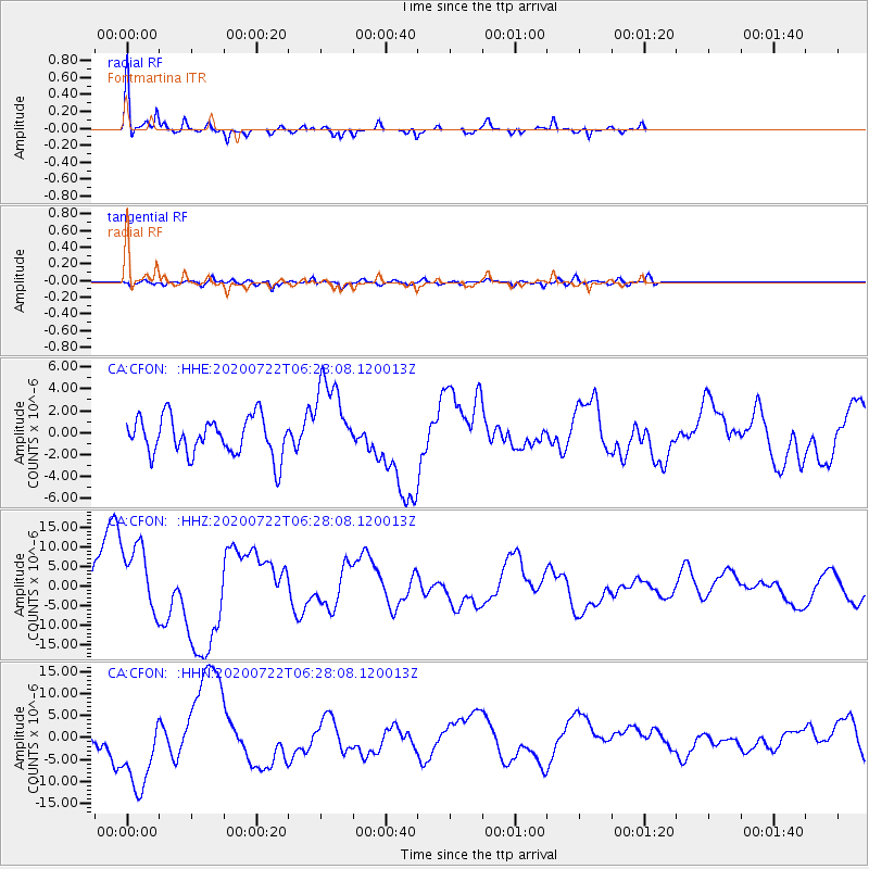
Signal To Noise
| Channel | StoN | STA | LTA |
| CA:CFON: :HHZ:20200722T06:28:08.120013Z | 1.4851842 | 9.219302E-6 | 6.207514E-6 |
| CA:CFON: :HHN:20200722T06:28:08.120013Z | 2.3046932 | 9.210288E-6 | 3.996319E-6 |
| CA:CFON: :HHE:20200722T06:28:08.120013Z | 2.1959643 | 3.7837146E-6 | 1.7230309E-6 |
| Arrivals |
| Ps | 3.1 SECOND |
| PpPs | 13 SECOND |
| PsPs/PpSs | 16 SECOND |


