You are here: Home > Network List > CA - Catalan Seismic Network Stations List
> Station CSOR Soriguera > Earthquake Result Viewer
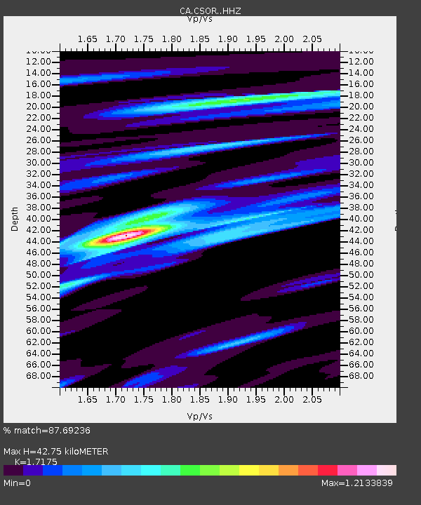
CSOR Soriguera - Earthquake Result Viewer
| Earthquake location: |
South Of Alaska |
| Earthquake latitude/longitude: |
54.9/-159.0 |
| Earthquake time(UTC): |
2020/07/22 (204) 06:16:18 GMT |
| Earthquake Depth: |
18 km |
| Earthquake Magnitude: |
6.1 mb |
| Earthquake Catalog/Contributor: |
NEIC PDE/us |
|
| Network: |
CA Catalan Seismic Network |
| Station: |
CSOR Soriguera |
| Lat/Lon: |
42.37 N/1.13 E |
| Elevation: |
1227 m |
|
| Distance: |
81.6 deg |
| Az: |
14.716 deg |
| Baz: |
348.588 deg |
| Ray Param: |
0.047464527 |
| Estimated Moho Depth: |
42.75 km |
| Estimated Crust Vp/Vs: |
1.72 |
| Assumed Crust Vp: |
6.416 km/s |
| Estimated Crust Vs: |
3.736 km/s |
| Estimated Crust Poisson's Ratio: |
0.24 |
|
| Radial Match: |
87.69236 % |
| Radial Bump: |
400 |
| Transverse Match: |
51.828934 % |
| Transverse Bump: |
400 |
| SOD ConfigId: |
21709731 |
| Insert Time: |
2020-08-05 06:46:20.448 +0000 |
| GWidth: |
2.5 |
| Max Bumps: |
400 |
| Tol: |
0.001 |
|

Signal To Noise
| Channel | StoN | STA | LTA |
| CA:CSOR: :HHZ:20200722T06:28:04.000018Z | 1.4171584 | 8.533131E-6 | 6.021297E-6 |
| CA:CSOR: :HHN:20200722T06:28:04.000018Z | 1.9380383 | 6.6527973E-6 | 3.4327481E-6 |
| CA:CSOR: :HHE:20200722T06:28:04.000018Z | 1.0230999 | 1.957576E-6 | 1.9133772E-6 |
| Arrivals |
| Ps | 4.9 SECOND |
| PpPs | 18 SECOND |
| PsPs/PpSs | 23 SECOND |


