You are here: Home > Network List > CA - Catalan Seismic Network Stations List
> Station EBR Ebre > Earthquake Result Viewer
EBR Ebre - Earthquake Result Viewer

| Earthquake location: |
South Of Alaska |
| Earthquake latitude/longitude: |
54.9/-159.0 |
| Earthquake time(UTC): |
2020/07/22 (204) 06:16:18 GMT |
| Earthquake Depth: |
18 km |
| Earthquake Magnitude: |
6.1 mb |
| Earthquake Catalog/Contributor: |
NEIC PDE/us |
|
| Network: |
CA Catalan Seismic Network |
| Station: |
EBR Ebre |
| Lat/Lon: |
40.82 N/0.49 E |
| Elevation: |
36 m |
|
| Distance: |
83.0 deg |
| Az: |
15.504 deg |
| Baz: |
348.271 deg |
| Ray Param: |
0.046468228 |
| Estimated Moho Depth: |
24.5 km |
| Estimated Crust Vp/Vs: |
1.83 |
| Assumed Crust Vp: |
6.391 km/s |
| Estimated Crust Vs: |
3.492 km/s |
| Estimated Crust Poisson's Ratio: |
0.29 |
|
| Radial Match: |
83.96957 % |
| Radial Bump: |
400 |
| Transverse Match: |
48.91863 % |
| Transverse Bump: |
400 |
| SOD ConfigId: |
21709731 |
| Insert Time: |
2020-08-05 06:46:22.371 +0000 |
| GWidth: |
2.5 |
| Max Bumps: |
400 |
| Tol: |
0.001 |
|
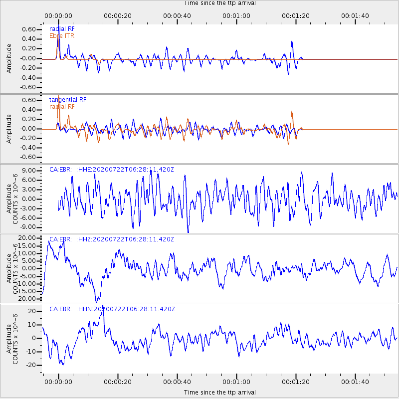
Signal To Noise
| Channel | StoN | STA | LTA |
| CA:EBR: :HHZ:20200722T06:28:11.420Z | 1.9416301 | 1.1955699E-5 | 6.157558E-6 |
| CA:EBR: :HHN:20200722T06:28:11.420Z | 2.3958766 | 1.3412769E-5 | 5.598272E-6 |
| CA:EBR: :HHE:20200722T06:28:11.420Z | 1.4240888 | 4.661588E-6 | 3.2733828E-6 |
| Arrivals |
| Ps | 3.3 SECOND |
| PpPs | 11 SECOND |
| PsPs/PpSs | 14 SECOND |


