You are here: Home > Network List > CI - Caltech Regional Seismic Network Stations List
> Station SWS Sam W. Stewart, Westmorland, CA, USA > Earthquake Result Viewer
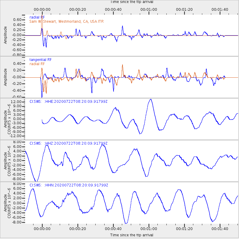
SWS Sam W. Stewart, Westmorland, CA, USA - Earthquake Result Viewer
*The percent match for this event was below the threshold and hence no stack was calculated.
| Earthquake location: |
Alaska Peninsula |
| Earthquake latitude/longitude: |
55.2/-159.4 |
| Earthquake time(UTC): |
2020/07/22 (204) 08:13:29 GMT |
| Earthquake Depth: |
37 km |
| Earthquake Magnitude: |
5.8 mb |
| Earthquake Catalog/Contributor: |
NEIC PDE/us |
|
| Network: |
CI Caltech Regional Seismic Network |
| Station: |
SWS Sam W. Stewart, Westmorland, CA, USA |
| Lat/Lon: |
32.94 N/115.80 W |
| Elevation: |
140 m |
|
| Distance: |
37.6 deg |
| Az: |
108.077 deg |
| Baz: |
319.628 deg |
| Ray Param: |
$rayparam |
*The percent match for this event was below the threshold and hence was not used in the summary stack. |
|
| Radial Match: |
63.75209 % |
| Radial Bump: |
400 |
| Transverse Match: |
62.61006 % |
| Transverse Bump: |
351 |
| SOD ConfigId: |
21709731 |
| Insert Time: |
2020-08-05 08:16:44.360 +0000 |
| GWidth: |
2.5 |
| Max Bumps: |
400 |
| Tol: |
0.001 |
|
Signal To Noise
| Channel | StoN | STA | LTA |
| CI:SWS: :HHZ:20200722T08:20:09.91799Z | 1.6779168 | 4.544903E-6 | 2.708658E-6 |
| CI:SWS: :HHN:20200722T08:20:09.91799Z | 1.3331975 | 3.3402985E-6 | 2.5054792E-6 |
| CI:SWS: :HHE:20200722T08:20:09.91799Z | 0.6550063 | 1.2388101E-6 | 1.891295E-6 |
| Arrivals |
| Ps | |
| PpPs | |
| PsPs/PpSs | |


