You are here: Home > Network List > US - United States National Seismic Network Stations List
> Station WMOK Wichita Mountains, Oklahoma, USA > Earthquake Result Viewer
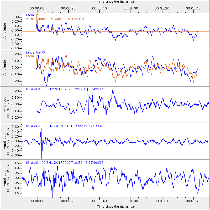
WMOK Wichita Mountains, Oklahoma, USA - Earthquake Result Viewer
*The percent match for this event was below the threshold and hence no stack was calculated.
| Earthquake location: |
Sea Of Japan |
| Earthquake latitude/longitude: |
40.9/131.6 |
| Earthquake time(UTC): |
2017/07/12 (193) 19:48:07 GMT |
| Earthquake Depth: |
538 km |
| Earthquake Magnitude: |
5.8 Mww |
| Earthquake Catalog/Contributor: |
NEIC PDE/us |
|
| Network: |
US United States National Seismic Network |
| Station: |
WMOK Wichita Mountains, Oklahoma, USA |
| Lat/Lon: |
34.74 N/98.78 W |
| Elevation: |
486 m |
|
| Distance: |
91.6 deg |
| Az: |
39.417 deg |
| Baz: |
324.211 deg |
| Ray Param: |
$rayparam |
*The percent match for this event was below the threshold and hence was not used in the summary stack. |
|
| Radial Match: |
49.58171 % |
| Radial Bump: |
400 |
| Transverse Match: |
46.09402 % |
| Transverse Bump: |
400 |
| SOD ConfigId: |
2140511 |
| Insert Time: |
2017-07-26 11:51:27.522 +0000 |
| GWidth: |
2.5 |
| Max Bumps: |
400 |
| Tol: |
0.001 |
|
Signal To Noise
| Channel | StoN | STA | LTA |
| US:WMOK:00:BHZ:20170712T19:59:45.574993Z | 2.5107186 | 2.5117964E-7 | 1.0004293E-7 |
| US:WMOK:00:BH1:20170712T19:59:45.574993Z | 1.3744535 | 5.772667E-8 | 4.1999723E-8 |
| US:WMOK:00:BH2:20170712T19:59:45.574993Z | 1.9735628 | 1.1480967E-7 | 5.817381E-8 |
| Arrivals |
| Ps | |
| PpPs | |
| PsPs/PpSs | |


