You are here: Home > Network List > AK - Alaska Regional Network Stations List
> Station MCAR McCarthy VSAT, AK, USA > Earthquake Result Viewer
MCAR McCarthy VSAT, AK, USA - Earthquake Result Viewer
| Earthquake location: |
Xizang |
| Earthquake latitude/longitude: |
33.1/86.8 |
| Earthquake time(UTC): |
2020/07/22 (204) 20:07:19 GMT |
| Earthquake Depth: |
10 km |
| Earthquake Magnitude: |
6.3 mww |
| Earthquake Catalog/Contributor: |
NEIC PDE/us |
|
| Network: |
AK Alaska Regional Network |
| Station: |
MCAR McCarthy VSAT, AK, USA |
| Lat/Lon: |
61.38 N/143.02 W |
| Elevation: |
447 m |
|
| Distance: |
77.5 deg |
| Az: |
22.147 deg |
| Baz: |
318.923 deg |
| Ray Param: |
0.050286174 |
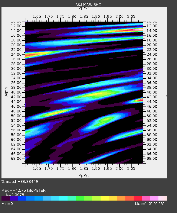
| Estimated Moho Depth: |
42.75 km |
| Estimated Crust Vp/Vs: |
2.10 |
| Assumed Crust Vp: |
6.566 km/s |
| Estimated Crust Vs: |
3.13 km/s |
| Estimated Crust Poisson's Ratio: |
0.35 |
|
| Radial Match: |
88.38449 % |
| Radial Bump: |
400 |
| Transverse Match: |
77.36452 % |
| Transverse Bump: |
400 |
| SOD ConfigId: |
21709731 |
| Insert Time: |
2020-08-05 20:10:00.131 +0000 |
| GWidth: |
2.5 |
| Max Bumps: |
400 |
| Tol: |
0.001 |
|

Signal To Noise
| Channel | StoN | STA | LTA |
| AK:MCAR: :BHZ:20200722T20:18:43.868003Z | 28.285625 | 2.5473876E-6 | 9.0059444E-8 |
| AK:MCAR: :BHN:20200722T20:18:43.868003Z | 10.496564 | 7.8211247E-7 | 7.451129E-8 |
| AK:MCAR: :BHE:20200722T20:18:43.868003Z | 11.170196 | 7.5866365E-7 | 6.791857E-8 |
| Arrivals |
| Ps | 7.3 SECOND |
| PpPs | 20 SECOND |
| PsPs/PpSs | 27 SECOND |


