You are here: Home > Network List > AK - Alaska Regional Network Stations List
> Station PPLA Purkeypile > Earthquake Result Viewer
PPLA Purkeypile - Earthquake Result Viewer
| Earthquake location: |
Xizang |
| Earthquake latitude/longitude: |
33.1/86.8 |
| Earthquake time(UTC): |
2020/07/22 (204) 20:07:19 GMT |
| Earthquake Depth: |
10 km |
| Earthquake Magnitude: |
6.3 mww |
| Earthquake Catalog/Contributor: |
NEIC PDE/us |
|
| Network: |
AK Alaska Regional Network |
| Station: |
PPLA Purkeypile |
| Lat/Lon: |
62.90 N/152.19 W |
| Elevation: |
1519 m |
|
| Distance: |
73.4 deg |
| Az: |
24.192 deg |
| Baz: |
311.344 deg |
| Ray Param: |
0.053035796 |
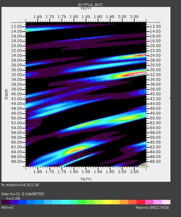
| Estimated Moho Depth: |
31.0 km |
| Estimated Crust Vp/Vs: |
2.09 |
| Assumed Crust Vp: |
6.566 km/s |
| Estimated Crust Vs: |
3.142 km/s |
| Estimated Crust Poisson's Ratio: |
0.35 |
|
| Radial Match: |
84.82138 % |
| Radial Bump: |
393 |
| Transverse Match: |
77.34149 % |
| Transverse Bump: |
400 |
| SOD ConfigId: |
21709731 |
| Insert Time: |
2020-08-05 20:10:25.462 +0000 |
| GWidth: |
2.5 |
| Max Bumps: |
400 |
| Tol: |
0.001 |
|

Signal To Noise
| Channel | StoN | STA | LTA |
| AK:PPLA: :BHZ:20200722T20:18:20.347983Z | 39.92142 | 3.3779656E-6 | 8.4615365E-8 |
| AK:PPLA: :BHN:20200722T20:18:20.347983Z | 13.68506 | 9.333522E-7 | 6.8202276E-8 |
| AK:PPLA: :BHE:20200722T20:18:20.347983Z | 14.720808 | 9.4122953E-7 | 6.3938714E-8 |
| Arrivals |
| Ps | 5.3 SECOND |
| PpPs | 14 SECOND |
| PsPs/PpSs | 19 SECOND |


