You are here: Home > Network List > AK - Alaska Regional Network Stations List
> Station L17K Donlin, AK, USA > Earthquake Result Viewer
L17K Donlin, AK, USA - Earthquake Result Viewer
| Earthquake location: |
Xizang |
| Earthquake latitude/longitude: |
33.1/86.8 |
| Earthquake time(UTC): |
2020/07/22 (204) 20:07:19 GMT |
| Earthquake Depth: |
10 km |
| Earthquake Magnitude: |
6.3 mww |
| Earthquake Catalog/Contributor: |
NEIC PDE/us |
|
| Network: |
AK Alaska Regional Network |
| Station: |
L17K Donlin, AK, USA |
| Lat/Lon: |
62.13 N/158.30 W |
| Elevation: |
338 m |
|
| Distance: |
71.7 deg |
| Az: |
26.685 deg |
| Baz: |
306.678 deg |
| Ray Param: |
0.0541826 |
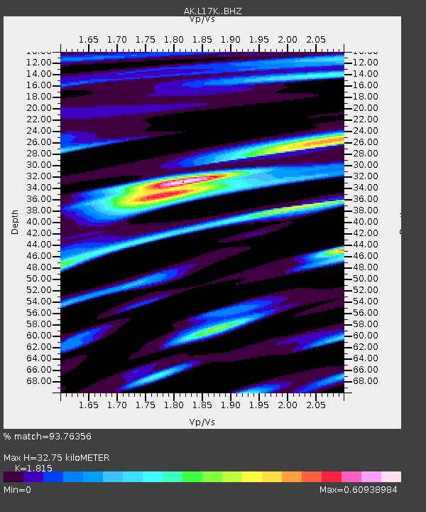
| Estimated Moho Depth: |
32.75 km |
| Estimated Crust Vp/Vs: |
1.82 |
| Assumed Crust Vp: |
6.276 km/s |
| Estimated Crust Vs: |
3.458 km/s |
| Estimated Crust Poisson's Ratio: |
0.28 |
|
| Radial Match: |
93.76356 % |
| Radial Bump: |
338 |
| Transverse Match: |
78.67152 % |
| Transverse Bump: |
385 |
| SOD ConfigId: |
21709731 |
| Insert Time: |
2020-08-05 20:11:11.922 +0000 |
| GWidth: |
2.5 |
| Max Bumps: |
400 |
| Tol: |
0.001 |
|

Signal To Noise
| Channel | StoN | STA | LTA |
| AK:L17K: :BHZ:20200722T20:18:10.120017Z | 30.272207 | 2.3237199E-6 | 7.6760834E-8 |
| AK:L17K: :BHN:20200722T20:18:10.120017Z | 13.200327 | 6.7291415E-7 | 5.0977082E-8 |
| AK:L17K: :BHE:20200722T20:18:10.120017Z | 14.228676 | 6.850919E-7 | 4.8148678E-8 |
| Arrivals |
| Ps | 4.4 SECOND |
| PpPs | 14 SECOND |
| PsPs/PpSs | 19 SECOND |


