You are here: Home > Network List > AV - Alaska Volcano Observatory Stations List
> Station ACH Angle Creek Headwaters, Katmai, Alaska > Earthquake Result Viewer
ACH Angle Creek Headwaters, Katmai, Alaska - Earthquake Result Viewer
| Earthquake location: |
Xizang |
| Earthquake latitude/longitude: |
33.1/86.8 |
| Earthquake time(UTC): |
2020/07/22 (204) 20:07:19 GMT |
| Earthquake Depth: |
10 km |
| Earthquake Magnitude: |
6.3 mww |
| Earthquake Catalog/Contributor: |
NEIC PDE/us |
|
| Network: |
AV Alaska Volcano Observatory |
| Station: |
ACH Angle Creek Headwaters, Katmai, Alaska |
| Lat/Lon: |
58.21 N/155.33 W |
| Elevation: |
960 m |
|
| Distance: |
75.3 deg |
| Az: |
28.948 deg |
| Baz: |
309.896 deg |
| Ray Param: |
0.051777363 |
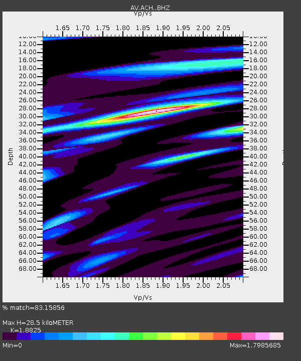
| Estimated Moho Depth: |
28.5 km |
| Estimated Crust Vp/Vs: |
1.88 |
| Assumed Crust Vp: |
6.438 km/s |
| Estimated Crust Vs: |
3.42 km/s |
| Estimated Crust Poisson's Ratio: |
0.30 |
|
| Radial Match: |
83.15856 % |
| Radial Bump: |
400 |
| Transverse Match: |
64.75624 % |
| Transverse Bump: |
400 |
| SOD ConfigId: |
21709731 |
| Insert Time: |
2020-08-05 20:12:26.857 +0000 |
| GWidth: |
2.5 |
| Max Bumps: |
400 |
| Tol: |
0.001 |
|

Signal To Noise
| Channel | StoN | STA | LTA |
| AV:ACH: :BHZ:20200722T20:18:31.287986Z | 35.661304 | 1.41471E-6 | 3.967073E-8 |
| AV:ACH: :BHN:20200722T20:18:31.287986Z | 5.7002587 | 7.798297E-7 | 1.3680602E-7 |
| AV:ACH: :BHE:20200722T20:18:31.287986Z | 4.423698 | 6.4450325E-7 | 1.4569332E-7 |
| Arrivals |
| Ps | 4.0 SECOND |
| PpPs | 12 SECOND |
| PsPs/PpSs | 16 SECOND |


