You are here: Home > Network List > TA - USArray Transportable Network (new EarthScope stations) Stations List
> Station C17K DeLong Mountains, AK, USA > Earthquake Result Viewer
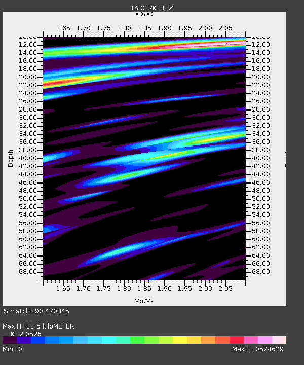
C17K DeLong Mountains, AK, USA - Earthquake Result Viewer
| Earthquake location: |
Xizang |
| Earthquake latitude/longitude: |
33.1/86.8 |
| Earthquake time(UTC): |
2020/07/22 (204) 20:07:19 GMT |
| Earthquake Depth: |
10 km |
| Earthquake Magnitude: |
6.3 mww |
| Earthquake Catalog/Contributor: |
NEIC PDE/us |
|
| Network: |
TA USArray Transportable Network (new EarthScope stations) |
| Station: |
C17K DeLong Mountains, AK, USA |
| Lat/Lon: |
68.48 N/163.18 W |
| Elevation: |
498 m |
|
| Distance: |
66.4 deg |
| Az: |
22.233 deg |
| Baz: |
300.648 deg |
| Ray Param: |
0.05761866 |
| Estimated Moho Depth: |
11.5 km |
| Estimated Crust Vp/Vs: |
2.05 |
| Assumed Crust Vp: |
5.906 km/s |
| Estimated Crust Vs: |
2.878 km/s |
| Estimated Crust Poisson's Ratio: |
0.34 |
|
| Radial Match: |
90.470345 % |
| Radial Bump: |
400 |
| Transverse Match: |
87.784615 % |
| Transverse Bump: |
400 |
| SOD ConfigId: |
21709731 |
| Insert Time: |
2020-08-05 20:24:56.302 +0000 |
| GWidth: |
2.5 |
| Max Bumps: |
400 |
| Tol: |
0.001 |
|

Signal To Noise
| Channel | StoN | STA | LTA |
| TA:C17K: :BHZ:20200722T20:17:37.699973Z | 46.687103 | 3.684079E-6 | 7.890999E-8 |
| TA:C17K: :BHN:20200722T20:17:37.699973Z | 10.456308 | 6.9902075E-7 | 6.6851584E-8 |
| TA:C17K: :BHE:20200722T20:17:37.699973Z | 12.82114 | 8.2805064E-7 | 6.458479E-8 |
| Arrivals |
| Ps | 2.1 SECOND |
| PpPs | 5.8 SECOND |
| PsPs/PpSs | 7.9 SECOND |


