You are here: Home > Network List > TA - USArray Transportable Network (new EarthScope stations) Stations List
> Station C19K Lookout Ridge, AK, USA > Earthquake Result Viewer
C19K Lookout Ridge, AK, USA - Earthquake Result Viewer
| Earthquake location: |
Xizang |
| Earthquake latitude/longitude: |
33.1/86.8 |
| Earthquake time(UTC): |
2020/07/22 (204) 20:07:19 GMT |
| Earthquake Depth: |
10 km |
| Earthquake Magnitude: |
6.3 mww |
| Earthquake Catalog/Contributor: |
NEIC PDE/us |
|
| Network: |
TA USArray Transportable Network (new EarthScope stations) |
| Station: |
C19K Lookout Ridge, AK, USA |
| Lat/Lon: |
69.10 N/159.59 W |
| Elevation: |
745 m |
|
| Distance: |
67.2 deg |
| Az: |
20.896 deg |
| Baz: |
303.466 deg |
| Ray Param: |
0.057112675 |
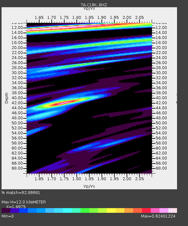
| Estimated Moho Depth: |
12.0 km |
| Estimated Crust Vp/Vs: |
1.70 |
| Assumed Crust Vp: |
6.221 km/s |
| Estimated Crust Vs: |
3.665 km/s |
| Estimated Crust Poisson's Ratio: |
0.23 |
|
| Radial Match: |
92.89981 % |
| Radial Bump: |
400 |
| Transverse Match: |
83.749886 % |
| Transverse Bump: |
400 |
| SOD ConfigId: |
21709731 |
| Insert Time: |
2020-08-05 20:24:59.261 +0000 |
| GWidth: |
2.5 |
| Max Bumps: |
400 |
| Tol: |
0.001 |
|

Signal To Noise
| Channel | StoN | STA | LTA |
| TA:C19K: :BHZ:20200722T20:17:42.599998Z | 64.575676 | 3.2294383E-6 | 5.0010136E-8 |
| TA:C19K: :BHN:20200722T20:17:42.599998Z | 9.425069 | 4.1808E-7 | 4.43583E-8 |
| TA:C19K: :BHE:20200722T20:17:42.599998Z | 16.9813 | 7.57447E-7 | 4.460477E-8 |
| Arrivals |
| Ps | 1.4 SECOND |
| PpPs | 5.0 SECOND |
| PsPs/PpSs | 6.4 SECOND |


